Catalog Archive
Auction 179, Lot 145

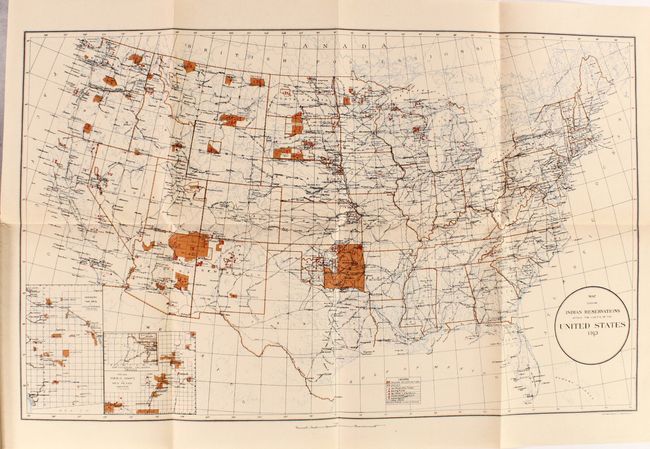
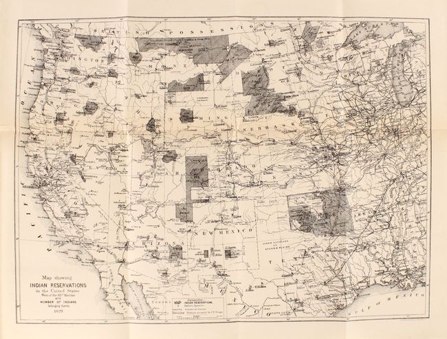
"Map Showing Indian Reservations Within the Limits of the United States 1913 [and] Map Showing Indian Reservations in the United States... [in] The American Indian in the United States - Period 1850-1914",

Subject: United States, Indians

Period: 1914 (published)

Publication:

Color: Printed Color

Size:
7.3 x 9.9 inches
18.5 x 25.1 cm
Download High Resolution Image
(or just click on image to launch the Zoom viewer)

This 440-page volume was written by Warren K. Moorehead, who is regarded as the "Dean of American Archaeology." The volume is his celebrated treatise on Native Americans of the United States, with an examination of their history, culture, and fate during the late 19th century opening of the mid-continent and west to non-native settlers. Moorehead's work describes many prominent Indian tribes (Sioux, Choctaw, Chickasaw, Apache, Pueblo, and more), and relates incidents that affected their progress or survival including the near-extermination of the buffalo, broken treaties, warfare, starvation, etc. There are 92 illustrations within the text along with two folding maps by Norris-Peters that demonstrate the shrinking footprint of the American Indian in the United States:

A. Map Showing Indian Reservations Within the Limits of the United States, dated 1913, printed color (24.3 x 15.0").
B. Map Showing Indian Reservations in the United States West of the 83rd Meridian and Number of Indians Belonging Thereto, dated 1879 (but a later issue for this publication - circa 1914), black & white (18.0 x 13.0").

Hardbound in green cloth with gilt title and illustration on the front cover.

References:

Condition: A

The folding maps are near fine with tiny binding tears confined to the left blank margins. Text is clean with occasional ink notations mostly in the margins, and a former owner's bookplate is on the front pastedown. Covers are lightly worn and the front hinge is starting.

Estimate: $180 - $220

Sold for: $500

Closed on 9/16/2020

Archived