Catalog Archive
Auction 178, Lot 89

Rare Map Presenting the "Rebel Colonies now the United States of America"

"A New and Correct Map of North America in Which the Places of the Principal Engagements During the Present War, Are Accurately Inserted...", Lodge, John

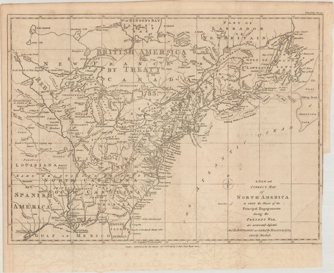
Subject: Eastern United States & Canada

Period: 1783 (published)

Publication: The Political Magazine

Color: Black & White

Size:
14.8 x 10.9 inches
37.6 x 27.7 cm
Download High Resolution Image
(or just click on image to launch the Zoom viewer)

This is the rare and important later state of this map, published by John Bew in February 1783, just one month after the signing of the Preliminary Articles of Peace in Versailles. It is one of the few maps published in the aftermath of the American Revolution to detail the new boundaries before the signing of the Treaty of Paris on September 3, 1783. The map shows the Rebel Colonies Now the United States of America and British America by Treaty 1783 in Canada. Spanish America is identified in present-day Texas, where Cenis is located, and in Florida (Great Britain ceded East Florida to Spain as part of the treaty). Based on the cartography of Thomas Jefferys, the map covers from James Bay to the Gulf of Mexico and provides many details about the frontier wilderness, including numerous early forts, Indian villages and tribal territories. The mythical islands in Lake Superior are a hold-over from earlier French cartographers. Earl Granville's Property in North Carolina is shown extending beyond the Mississippi River.

This example is augmented by the accompanying text from the February 1783 issue of The Political Magazine covering the map and the "debates on the Peace."

References: Jolly #POL-69.

Condition: B+

Issued folding on watermarked paper with light offsetting and an extraneous crease at lower right. There is a binding trim also at lower right with a tiny binding tear that just enters the border.

Estimate: $3,000 - $4,000

Sold for: $3,750

Closed on 6/10/2020

Archived