Catalog Archive
Auction 178, Lot 72

Blaeu's Only Map of Canada, Showing the Canadian Maritimes

"Extrema Americae Versus Boream, ubi Terra Nova Nova Francia, Adjacentiaqs", Blaeu, Johannes

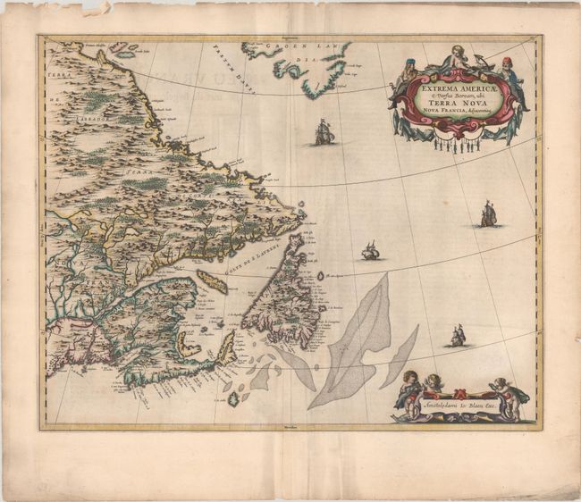
Subject: Eastern Canada

Period: 1664 (published)

Publication: Grooten Atlas

Color: Hand Color

Size:
22.3 x 17.5 inches
56.6 x 44.5 cm
Download High Resolution Image
(or just click on image to launch the Zoom viewer)

This handsome map of the Canadian Maritimes is based on Samuel de Champlain's great map of 1632, and augmented with place names from De Laet and Jansson. This is Blaeu's only map of Canada. It shows Nova Scotia, Newfoundland, the Gulf of St. Lawrence, Labrador and the Davis and Hudson Straits as well as the southern tip of Greenland and a portion of northern Maine. The elaborate cartouches symbolize the importance of the Grand Banks fisheries, which are boldly engraved on the map. Only five editions of the Atlas Maior, containing this map, were published prior to the fire that destroyed the Blaeu printing house in 1672. Thus the map is now quite scarce. Published in the Dutch text edition of the Atlas Maior.

References: Burden #371, Goss (Blaeu) p. 158; Kershaw #149; Van der Krogt (Vol. II) #9130:2.

Condition: B+

A dark impression with light printer's ink residue, some soiling and creasing adjacent to the centerfold, and a couple of other minor spots. The top edge of the sheet has heavy soiling and a number of chips and tears, all well away from the image.

Estimate: $1,900 - $2,200

Sold for: $1,400

Closed on 6/10/2020

Archived