Catalog Archive
Auction 178, Lot 27

Magnificent Early Map of the South Pole in Full Contemporary Color

"Polus Antarcticus", Hondius, Henricus
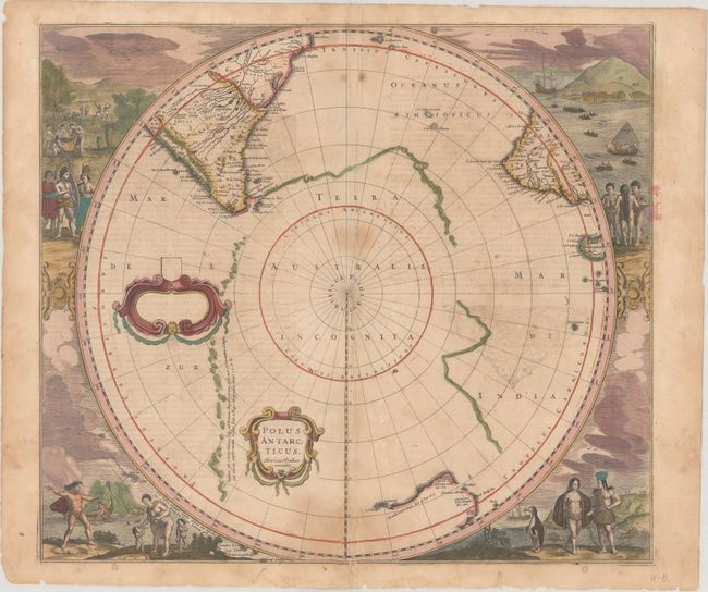
Subject: South Pole

Period: 1639 (circa)

Publication:

Color: Hand Color

Size:
19.5 x 17.2 inches
49.5 x 43.7 cm
Download High Resolution Image
(or just click on image to launch the Zoom viewer)

This early map of the South Pole is considered one of the earliest realistic maps of the Antarctic continent, which is partially delineated in a combination of coastline and strings of islands noted as first discovered by Magellan. The circular map also shows parts of South America, Africa, and Madagascar with the incomplete coastline of Australia. When first published in 1637, this was the first printed map to show the discovery of Pieter Nuyts' Land and was the best map of Australia prior to Tasman's discoveries. Early Dutch explorations in the region are noted. The map is surrounded by fabulous engravings of natives and early explorers. It also features an empty dedication cartouche at left. This is the first state of the map. French text on verso, published in either Nouveau Theatre du Monde (1639-44) or Nouvel Atlas ou Theatre du Monde (1646-49).

References: Tooley (MCC -2) #20; Tooley (Australia) #726; Van der Krogt (Vol. I) #0030:1.1.

Condition: B

Full contemporary color with scattered damp staining, some light spots, and some errant colorist's ink. Several tears and extraneous creases around the centerfold have been backed on verso with archival materials.

Estimate: $1,400 - $1,700

Unsold

Closed on 6/10/2020

Archived