Catalog Archive
Auction 177, Lot 93

The First Printed Map to Focus on New England and New France

"La Nuova Francia", Gastaldi/Ramusio

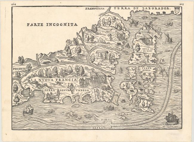
Subject: Northeastern United States & Canada

Period: 1565 (published)

Publication: Terzo Volume delle Navigationi et Viaggi

Color: Black & White

Size:
14.6 x 10.5 inches
37.1 x 26.7 cm
Download High Resolution Image
(or just click on image to launch the Zoom viewer)

This unusual map is the first to focus on the area of New England and New France and the first to use the name Nuova Francia. Derived from the Gastaldi's 1548 regional map, the cartography is based largely on Verrazzano and Cartier's reports resulting in a curious depiction of the Hudson and St. Lawrence rivers. Newfoundland is identified as Terra Nuova, below the large Isola de Demoni, appropriately decorated with demons. The area near New York Harbor is titled Angoulesme. Long Island, which Verrazzano imagined as a peninsula, is labeled Flora. Newport Bay is called Port Real and Narragansett Bay is Port du Refuge. A long, snake-like band, speculated to be an early representation of the Gulf Stream, marks the rich fishing banks. The map is populated with scenes of Native Americans hunting and fishing, elaborately engraved ships, and fanciful sea monsters. This example is the second state, as evidenced by the addition of weeping willow trees.

References: Augustyn & Cohen, pp. 18-19; Burden #25; Goss #8; Kershaw #15a; McCorkle #556.1; Mickwitz & Miekkavaara #641 Vol. III #4; Sabin #67741; Shirley (BL Atlases) G.RAMU-2a #5; Verner & Stuart-Stubbs #2.

Condition: A

A sharp impression on a bright watermarked sheet. There are a few small worm tracks around the centerfold at top that have been closed on verso with archival materials.

Estimate: $3,000 - $3,750

Sold for: $3,250

Closed on 4/29/2020

Archived