Catalog Archive
Auction 177, Lot 41

The First Printed Map to Reflect Coronado's Explorations in the Southwest

"Universale della Parte del Mondo Nuovamente Ritrovata", Gastaldi/Ramusio

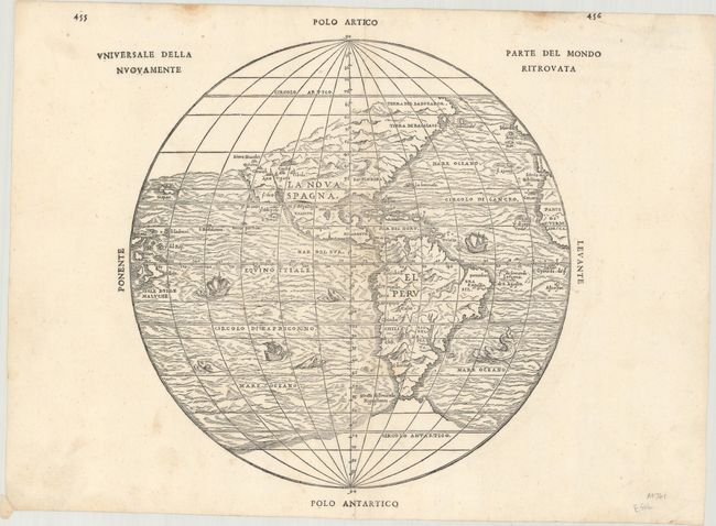
Subject: Western Hemisphere - America

Period: 1565 (published)

Publication: Terzo Volume delle Navigationi et Viaggi

Color: Black & White

Size:
11.9 x 11.5 inches
30.2 x 29.2 cm
Download High Resolution Image
(or just click on image to launch the Zoom viewer)

This extremely important map of the Americas includes the first mention of several names from the explorations of Coronado of 1540-42, including the elusive cities of Cibola and Quivira. The Sierra Nevadas appear for the first time, following the voyage of Juan Rodriguez Cabrillo in 1542. The map was originated by Gastaldi and is one of five he did for Ramusio. It leaves open the question of a land bridge from North America to Asia. This is the first issue from the second block, published in 1565. The first block, with identical geography, was destroyed in a fire at the printing establishment of Thomaso Guinti shortly after its publication in 1556. A nice example of this important and scarce map.

References: Burden #34; Mickwitz & Miekkavaara #641 Vol. III #9; Sabin #67741; Shirley (BL Atlases) G.RAMU-2a #10; Wagner (NW) #35; Wheat (TMW) #9.

Condition: A

A nice impression on watermarked paper with a few tiny worm holes near the centerfold that have been archivally backed on verso.

Estimate: $3,500 - $4,250

Sold for: $2,500

Closed on 4/29/2020

Archived