Catalog Archive
Auction 177, Lot 148

"A Plan of Captain Carvers Travels in the Interior Parts of North America in 1766 and 1767", Carver, Jonathan (Capt.)

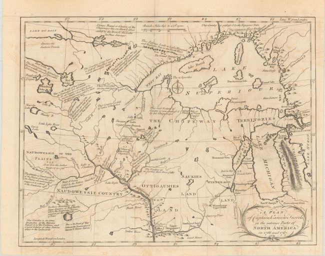
Subject: Colonial Central United States, Great Lakes

Period: 1781 (circa)

Publication: Travels Through the Interior Parts Of North America…

Color: Black & White

Size:
13.6 x 10.4 inches
34.5 x 26.4 cm
Download High Resolution Image
(or just click on image to launch the Zoom viewer)

A terrific early map of the region of today's Wisconsin and Minnesota. Filled with details and notations such as "Traders go no farther than these falls" and "seldom travel this way except War Parties" and many more. The route of Carver's travels are clearly shown along the Mississippi, Fox, Minnesota and St. Pierre rivers. The map extends from Michigan, here labeled Chipeways and Ottowas Land, to above Lake Superior and west to beyond the Minnesota River. After the French and Indian War the peace settlement gave the British eastern Minnesota, opening the vast territory to their fur traders. Carver spent the winter of 1766-67 with the Sioux on the Minnesota River. He then joined Capt. James Tute's expedition as the mapmaker. Tute's plan was to cross the continent in quest of the Northwest Passage. The plan was not successful but their explorations led Carver to later publish an account of his travels. Carver is credited with traveling farther into the unknown West than any other English explorer before the Revolution. A very early and seldom seen map.

References: Howes #C-215; Rumsey #0131; Wheat (TMW) #175.

Condition: B+

Issued folding with light offsetting and toning.

Estimate: $600 - $750

Sold for: $1,200

Closed on 4/29/2020

Archived