Catalog Archive
Auction 176, Lot 4

"Mappe-Monde ou Carte Generale du Globe Terrestre Representee en Deux Plan-Hemispheres...", Sanson/Mariette
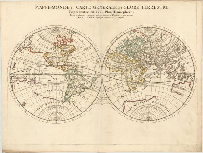
Subject: World

Period: 1678 (dated)

Publication:

Color: Hand Color

Size:
22.3 x 16.6 inches
56.6 x 42.2 cm
Download High Resolution Image
(or just click on image to launch the Zoom viewer)

This simple, yet elegant map is based on Nicolas Sanson's world map of 1651. Nicolas drew this map for his 1660 atlas, and after his death in 1667, his sons Guillaume and Adrien used it in their atlases of 1669 and 1678. This edition shows Australia with a bit more definition, along with Tasmania and a small portion of New Zealand's coastline. It is the first map to indicate N. Danemarck west of the Hudson Bay, here named the Mer Christiane. California is shown as an island, and Acoma and Santa Fe are noted in the Southwest, with Acoma shown correctly atop a mesa. The coastline of Asia is shown with the discoveries of De Vries noted, including Terre de Iesso or Ieco, and a land called Yupi. The Great Lakes are not updated from the 1651 version; all five lakes are not shown here. The map is typical of Sanson's "scientific" style of cartography that did not bother with decorative elements nor fanciful geography. It was published in conjunction with Pierre Mariette (father and son), who published many of Sanson's works after 1645.

References: Shirley #419.

Condition: A

A crisp impression with contemporary outline color on watermarked paper with marginal soiling.

Estimate: $600 - $750

Sold for: $475

Closed on 2/12/2020

Archived