Catalog Archive
Auction 176, Lot 250

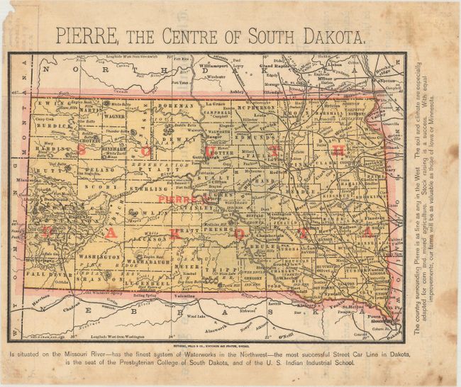
Persuasive Map Promoting Pierre as Capital of South Dakota

"Pierre, the Centre of South Dakota", Cram, George F. & Company

Subject: South Dakota

Period: 1889 (circa)

Publication:

Color: Printed Color

Size:
8.1 x 5.9 inches
20.6 x 15 cm
Download High Resolution Image
(or just click on image to launch the Zoom viewer)

This handsome small map was published circa April 1889, just seven months before South Dakota was admitted into the Union. It is a persuasive map advocating for Pierre as the capital city. On October 1, 1889, there was a vote to determine the capital for the state-to-be. Seven cities were on the ballot, including Watertown, Sioux Falls, and Harrison, a fictitious town invented by Watertown in a bid to capture votes, but the clear front runners were Pierre and Huron. Despite Huron's status as the temporary capital from 1885 to 1889 and its superior access to railroads, Pierre won by a significant margin. The city's name is printed in red ink in large letters with a star next to it. Text in the margins highlights the city's positive attributes: its position on the Missouri River; its agriculture-friendly soil and climate; its system of waterworks; its streetcar line; and more. The map delineates counties, Indian reservations, and railroads and names several towns and cities. On verso there is a charming illustration of an oversized pig named General Garfield, "the gentleman that pays the farmer's debt," with a note from James Baynes, editor and publisher of American Swineherd. Engraved by George F. Cram and printed by Chicago-based Pettibone, Wells & Co.

References:

Condition: B+

There are light spots and stains, mostly confined to the margins.

Estimate: $160 - $190

Sold for: $120

Closed on 2/12/2020

Archived