Catalog Archive
Auction 175, Lot 95

Scarce American Revolutionary War Map

"Carte du Theatre de la Guerre Presente en Amerique Dressee d'Apres les Nouvelles Cartes Anglaises", Denis, Louis

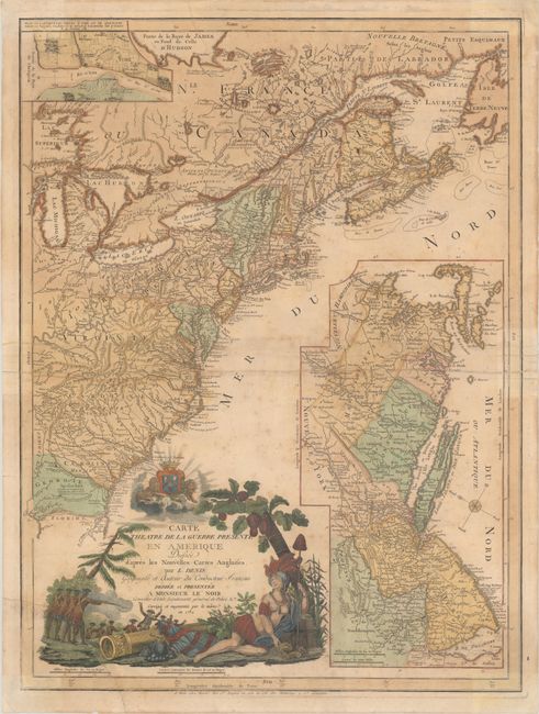
Subject: Colonial Eastern United States & Canada

Period: 1782 (dated)

Publication:

Color: Hand Color

Size:
19.6 x 26.3 inches
49.8 x 66.8 cm
Download High Resolution Image
(or just click on image to launch the Zoom viewer)

This is a scarce American Revolutionary War map covering the region from Newfoundland to northern Florida, but only as far west as Lake Michigan. It features a large inset of part of New England, New York, eastern Pennsylvania, and New Jersey that depicts the region most affected by the Revolution in 1779 when the map was first published. This second edition also includes a small inset of Yorktown, the site of General Cornwallis' surrender in October 1781. The map is filled with topographical information, boundaries, cities, towns, forts, Indian territory and villages, battlefields, trails and roads. The large title cartouche includes a battle scene and the personification of America as an Indian queen. Separately published by Basset.

References: Nebenzahl (Biblio) #192; cf. McCorkle #779.6; cf. Sellers & van Ee #737.

Condition: B

On watermarked paper with scattered foxing and a chip at lower left (3.5" x 4") that has been reattached on verso with archival materials. A number of small fold separations and edge tears have also been archivally repaired on verso.

Estimate: $3,000 - $3,750

Sold for: $1,800

Closed on 11/13/2019

Archived