Catalog Archive
Auction 175, Lot 81

First Printed Sea Chart of the Gulf of St. Lawrence

"Carta Particolare della Terra Nuova con la Gran Baia et il Fiume Grande della Canida ... D'America Car.a Prima", Dudley, Robert (Sir)

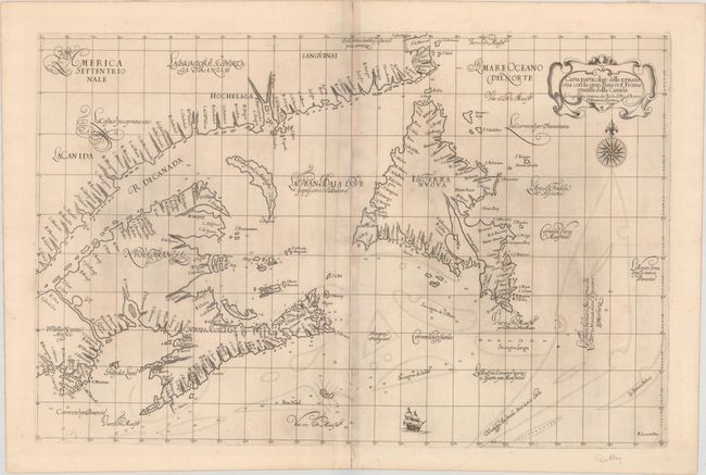
Subject: Eastern Canada

Period: 1647 (published)

Publication: Dell' Arcano del Mare

Color: Black & White

Size:
29.3 x 19.1 inches
74.4 x 48.5 cm
Download High Resolution Image
(or just click on image to launch the Zoom viewer)

Rare and important chart of the Gulf of St. Lawrence, Newfoundland, and the Maritimes. The cartography is likely based on a manuscript maps of the region, either by Nicholas Comberford, who lived in Florence at the same time as Dudley, or John Daniell's chart of 1637. This chart shows Newfoundland with new place names along the west coast and an exaggerated Avalon Peninsula. Although there are many place names along the coasts, nearly all of them relate to rivers and capes rather than settlements, with the exception of a few, such as Port Royal (Pr.to Royal) and Tadoussac (G:Tadusao). Also of interest is a waterway connecting the St. Lawrence River with the Bay of Fundy named R:di Sta. Croce (St. Croix River). Dudley's map was very influential, serving as the source map for many other cartographers through the end of the 18th century. The chart was elegantly engraved with fine calligraphy, a bold title cartouche, sailing ship and compass rose by the Florentine craftsman Arnoldo Lucini. Two sheets joined as issued. This is the first state.

Robert Dudley was the first Englishman to produce a sea atlas, Dell Arcano del Mare (Secrets of the Sea). Dudley, a skilled mathematician and navigator, was exiled from England and settled in Florence where his atlas was published. He introduced a totally new style for sea charts in the atlas with only lines of latitude and longitude and no rhumb lines. The charts were meticulously compiled from original sources and were both scientific and accurate for the time. This important atlas was the first sea atlas of the whole world; the first to use Mercator's projection throughout; the earliest to show the prevailing winds, currents and magnetic deviation; and the first to expound the advantages of Great Circle Sailing. In an introductory leaf found in one copy in the British Library, the engraver states that he worked on the plates in seclusion for twelve years in an obscure Tuscan village, using no less than 5,000 pounds of copper for the printing plates. It was only issued in two editions and the maps are rarely seen on the market. This map is from the first edition.

References: Burden #277; Kershaw #89; Shirley (BL Atlases) M.DUD-1a #114.

Condition: B+

A crisp impression on sturdy sheets with small lion watermarks, some printer's ink residue, and light toning along the centerfold as is common with Dudley charts. There are a couple of short separations between the two sheets.

Estimate: $3,500 - $4,500

Sold for: $2,500

Closed on 11/13/2019

Archived