Catalog Archive
Auction 175, Lot 46

Rare First Plate of Ortelius' Influential Map of the New World

"Americae sive Novi Orbis Nova Descriptio", Ortelius, Abraham

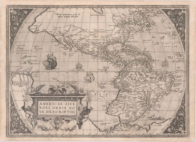
Subject: Western Hemisphere - America

Period: 1571 (published)

Publication: Theatrum Orbis Terrarum

Color: Black & White

Size:
20 x 14.4 inches
50.8 x 36.6 cm
Download High Resolution Image
(or just click on image to launch the Zoom viewer)

This is one of the most famous maps of America, and one that had enormous influence on the future cartography of the New World. Frans Hogenberg engraved this map, and it is primarily based on Gerard Mercator's great multi-sheet world map of 1569. The most recognizable features of the map are the bulbous Chilean coastline and the exaggerated breadth of the North American continent. North America shows a lengthy St. Lawrence River reaching across the continent to nearly meet the fictitious, westward flowing Tiguas Rio. The strategically placed title cartouche hides the unknown South Pacific and therefore most of the conjectural great southern continent, which is shown attached to both New Guinea and Tierra del Fuego.

This is from the uncommon first plate (second state), published in the second Latin edition of 1571. This plate had a relatively short life and was published only between 1570 and 1575.

References: Burden #39.2; Goss (NA) #11; Van den Broecke #9.2.

Condition: A

Crisp impression on a bright sheet with expert repairs to a tiny tear in the top border and to a few small chips along the edges of the sheet.

Estimate: $5,500 - $6,500

Sold for: $5,500

Closed on 11/13/2019

Archived