Catalog Archive
Auction 175, Lot 45

First State, First Issue of One of the Most Important 16th Century Maps of the New World

"Novae Insulae, XVII Nova Tabula", Munster, Sebastian

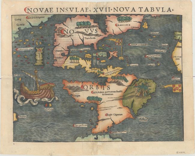
Subject: Western Hemisphere - America

Period: 1540 (published)

Publication: Geographia

Color: Hand Color

Size:
13.4 x 10 inches
34 x 25.4 cm
Download High Resolution Image
(or just click on image to launch the Zoom viewer)

Sebastian Munster (1489 - 1552) was one of the three most renowned cartographers of the sixteenth century, along with Mercator and Ortelius. Munster's Geographia and Cosmographia Universalis were two of the most widely read and influential books of the period. His editions of Ptolemy's Geographia, published between 1540 and 1552, were illustrated with 48 woodcut maps, the standard 27 Ptolemaic maps supplemented by 21 new maps. These new maps included a separate map of each of the known continents and marked the development of regional cartography in Central Europe. The antique geography was a prelude to Munster's major work, the Cosmographia, which was published in nearly 30 editions in six languages between 1544 and 1578 and then was revised and reissued by Sebastian Petri from 1588 to 1628. The Cosmographia was a geographical as well as historical and ethnographic description of the world. It contained the maps from the Geographia plus additional regional maps and city views with nearly 500 illustrations which made it one of the most popular pictorial encyclopedias of the sixteen century.

Extremely scarce, first issue of the first state of this important 16th century map of the New World. This map is often credited with popularizing the name America due to the popularity of Munster's Cosmographia and the numerous editions published in the sixteenth century. The influence of Marco Polo's 13th century explorations in Asia are evident with the 7448 islands in the North Pacific and Zipangri (Japan) shown only a short distance off the western coast of North America. The North American continent is very oddly shaped without a California landmass, and the eastern region is nearly bisected by a body of water, known as the Sea of Verrazzano. The Yucatan is still shown as an island, Cozumel is named nearby as Cozumela, and the lake at Temistitan is connected to the Gulf of Mexico. South America has a large bulge on the western coast, the Amazon River is very short, and cannibals inhabit the continent shown with the name Canibali next to a gruesome vignette with human limbs. The map is very decorative with Magellan's surviving ship Victoria appearing in the Pacific. The flags of Spain and Portugal depict their respective spheres of influence in the New World. This is the first state according to Burden, with no leaf motif before the title. Latin text on verso.

References: Burden #12, state 1; Kershaw #1.

Condition: B+

A dark impression with archival tissue reinforcements along the centerfold and the edges of the sheet to repair a few short fold separations, small chips, and some worm tracks mostly confined to the blank margins. There are two 1.5" long worm tracks at far right (within flag of Portugal) and far left (within ship), as well as one track entering 1/4" into the map image at right that have all been professionally repaired with a small amount of the image skillfully replaced in facsimile.

Estimate: $5,500 - $7,000

Sold for: $5,500

Closed on 11/13/2019

Archived