Catalog Archive
Auction 175, Lot 221

Rare Blueback Chart of Long Island

"[Untitled - Long Island]",

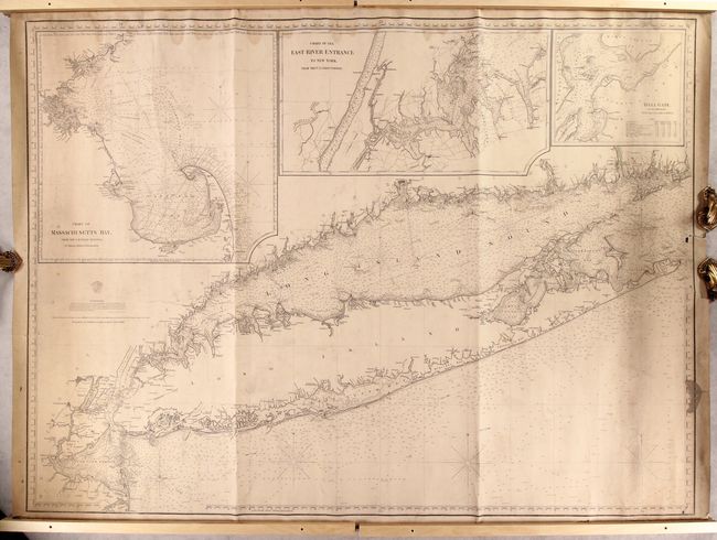
Subject: Long Island, New York

Period: 1860 (dated)

Publication:

Color: Black & White

Size:
47.5 x 35 inches
120.7 x 88.9 cm
Download High Resolution Image
(or just click on image to launch the Zoom viewer)

This rare blueback chart centers on Long Island and stretches from Sandy Hook to the Connecticut-Rhode Island border. It was published by the Brooklyn-based Charles Copley and Sons. A note claims that Copley drew the map with the "special permission of the Secretary of Treasury" using the U.S. Coast Survey's maps of the region as his source. It further states that it is "the most accurate chart of the Coast, that has yet been published." Just above this note is a logo for the "Hydrographic Office," suggesting the map is an official government-published chart. There is a plethora of navigational detail, including depth soundings, bottom types, routes, lighthouses, tidal information, and much more. There is little inland detail, but there are plenty of place names lining the coasts, with many cities appearing in miniature plan form. Three insets across the top of the chart provide impressive detail of Massachusetts Bay, the East River entrance to New York, and Hell Gate. Central Park appears on the East River inset; at the time of publication, the park was not yet completed and only parts of it were starting to open to the public.

References:

Condition: B

There is soiling, especially concentrated at left and right, and some old pencil notations in the map. Across the top of the chart there is light damp staining. An edge tear enters 2" into the image at right, with a small amount of image loss from an associated 1/4" chip. Wood pieces on sides in image are not attached to the map.

Estimate: $700 - $850

Sold for: $500

Closed on 11/13/2019

Archived