Catalog Archive
Auction 174, Lot 72

Scarce Map of the Americas - One of the Earliest Maps by Philip Lea

"A New Mapp of America Devided According to the Best and Latest Observations and Discoveries Wherein Are Described by Thear Proper Names the Seaverall Countries That Belonge to ye English...", Lea & Overton

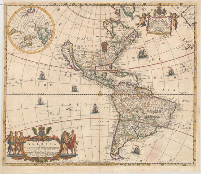
Subject: Western Hemisphere - America

Period: 1688 (circa)

Publication:

Color: Hand Color

Size:
22.2 x 18.8 inches
56.4 x 47.8 cm
Download High Resolution Image
(or just click on image to launch the Zoom viewer)

This scarce, separately published map of the Americas is one of the earliest productions of Philip Lea. In North America California is shown as an island on the Foxe model with two bays at the north end of the island, which is labeled New Albion. A dotted line continues the western coastline in a northeasterly direction to the supposed Straits of Anian. There is a single large lake in the Great Lakes region conveniently obscured by the British coat of arms. This is an unabashedly English publication showing the English Empire extending much beyond the Appalachian Mountains. The title cartouche enumerates the English possessions as New Scotland, Long Iland, N. York, N. Jarsey, Mary Land, Pensilvania, and Carolina. The South American cartography is largely based on Sanson with the mythical Lacke of Parime, an improved depiction of the La Plata River, the capitaineries of Brazil delineated, and a battle scene filling the interior. A map of the North Pole is inset at upper left reflecting the English interest in finding a Northwest Passage. The large title cartouche (copied from Blaeu) is flanked by Floridian warriors and royalty. The map is further adorned with numerous sailing ships and a decorative dedication cartouche to Henry, Duke of Beaufort. Drawn by Philip Lea, engraved by James Moxon, and published by Lea (at ye Atlas and Hercules in Cheapside) and Overton (at the White Horse without Newgate). A notation to the right of the cartouche identifies this as the second state. There is only one extant example of the first state and even the second state is rare.

References: Burden #593; McLaughlin #106; Pritchard & Taliaferro fig #245; Tooley (Amer) #54, p. 124.

Condition: B+

A crisp impression with contemporary outline color in the map and later color in the decorative elements. There are some light stains in unengraved areas of the Atlantic Ocean, and a tiny hole in both the upper centerfold and top border that are only visible when held to light. An old paper repair is confined to the bottom margin.

Estimate: $5,000 - $6,500

Sold for: $4,500

Closed on 9/11/2019

Archived