Catalog Archive
Auction 174, Lot 38

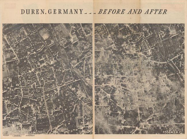
"Newsmap for the Armed Forces... [on verso] Duren, Germany - Before and After", U.S. Gov't Printing Office

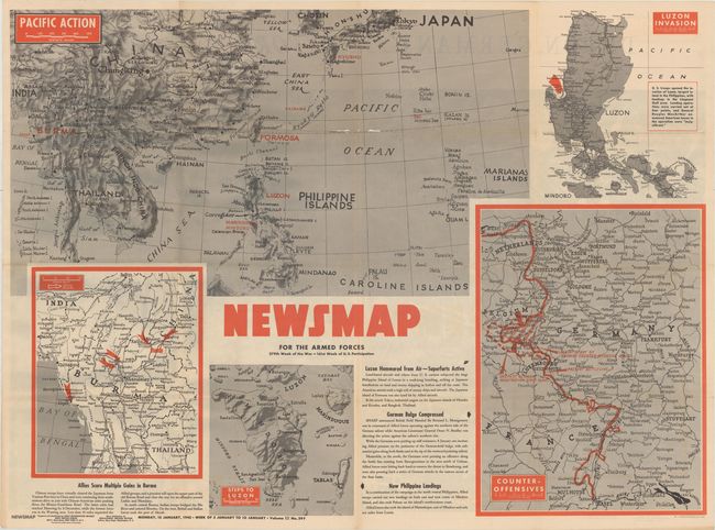
Subject: World, World War II

Period: 1945 (dated)

Publication:

Color: Printed Color

Size:
45.9 x 33.3 inches
116.6 x 84.6 cm
Download High Resolution Image
(or just click on image to launch the Zoom viewer)

This large-format map covers much of eastern and southeastern Asia and is appropriately called "Pacific Action." The map identifies those regions controlled by the Axis powers in red including Burma, Luzon, Formosa, and Okinawa to name a few, and offers excellent topographical detail with a three-dimensional quality. The sheet includes four inset maps of Burma, Luzon (2), and eastern Germany with descriptive text explaining the situation. This "Newsmap" was issued on Monday, January 15, 1945, and covers the news from January 3-10, 1945 - the 279th week of the war. Prepared by the Army Information Branch and issued by the U.S. Government Printing Office.

The verso of this "Newsmap" contains two large aerial views showing Duren, Germany before and after the devastating air raid of November 16, 1944 in which 500 bombers destroyed the city and killed an estimated 3,000 people. While the images are not crisp, they clearly convey the numerous bomb craters and stands testament to the horrors that total war produced in WWII by both sides.

From 1942-46, the U.S. Army published "newsmaps" to keep American troops updated on the war. These weekly posters were distributed and posted in every American installation in the world and were intentionally more visual than descriptive to help engage and motivate personnel.

References:

Condition: B+

Issued folding on a clean sheet with a number of small separations mostly at the fold junctions as is common for a map of this size. Along the upper horizontal fold is a 3" edge tear at left and a 4" separation at center.

Estimate: $150 - $180

Sold for: $60

Closed on 9/11/2019

Archived