Catalog Archive
Auction 174, Lot 26

"De Werelt Caart", Danckerts/Wetstein
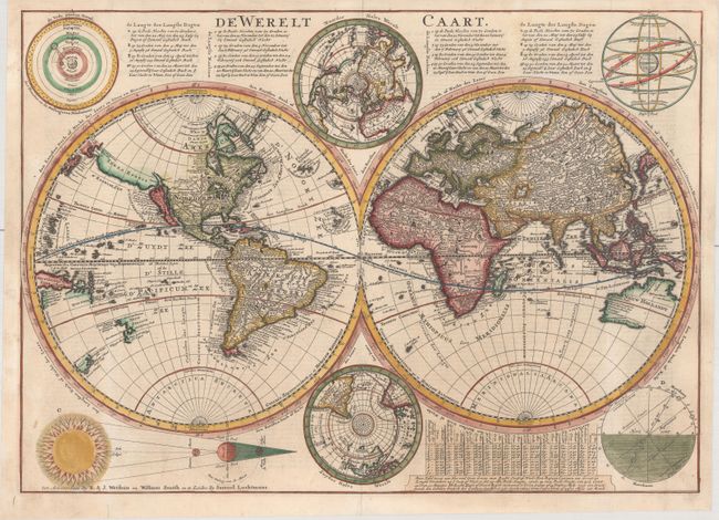
Subject: World

Period: 1728 (published)

Publication:

Color: Hand Color

Size:
20.3 x 14.5 inches
51.6 x 36.8 cm
Download High Resolution Image
(or just click on image to launch the Zoom viewer)

This is Cornelius Danckerts' second world map; his first being a re-engraved version of his father's map. This map is presented in the new scientific style popular at the turn of the 18th century. Danckerts retained the continental outlines from his father's map, including the island form of California. However, he updated information on the course of the Mississippi from recent French discoveries. Terra Esonis stretches across the Pacific from just above California nearly to Asia and the land of Yedso above Japan. Tasman's discoveries relating to Australia, New Zealand and Tasmania are shown in the Pacific. North and south polar projections appear at the top and bottom between the spheres. In each upper corner are illustrations of the Ptolemaic theory on the revolution of the planets and stars around the earth. In the lower corners are diagrams of the movement of the Sun throughout varying degrees of latitude, and a plan of the Sun, Moon and Earth during lunar and solar eclipses. There are extensive notations in Dutch at the top and a keyed table of latitude at the bottom. This is the second state, with the imprint at bottom changed to R. & J. Wetstein, William Smith, and Samuel Luchtmans. Dutch text on verso.

References: Shirley #615; Poortman & Augusteijn #159.

Condition: A

A sharp impression, issued folding on watermarked paper with professional repairs to several short fold separations and minor soiling.

Estimate: $1,100 - $1,400

Sold for: $800

Closed on 9/11/2019

Archived