Catalog Archive
Auction 174, Lot 173

"[Lot of 3] Johnson's California Territories of New Mexico and Utah [and] Johnson's California, Also Utah, Nevada, Colorado, New Mexico, and Arizona [and] Johnson's California, Also Utah, Nevada, Colorado, New Mexico, and Arizona",

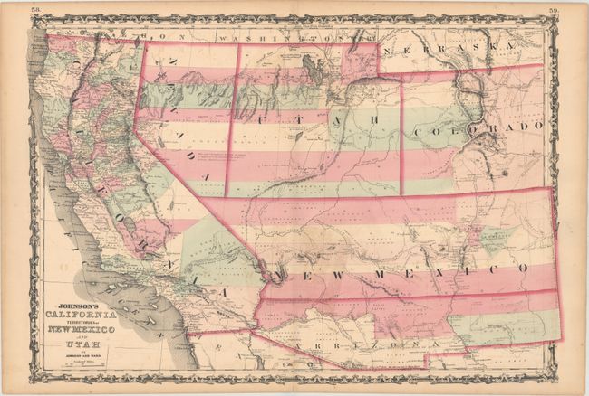
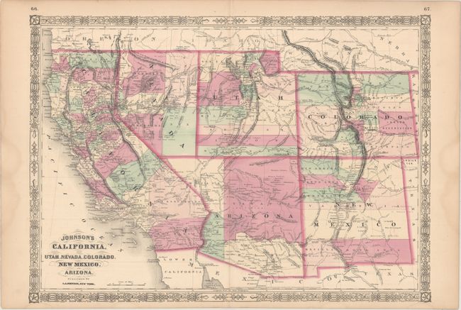
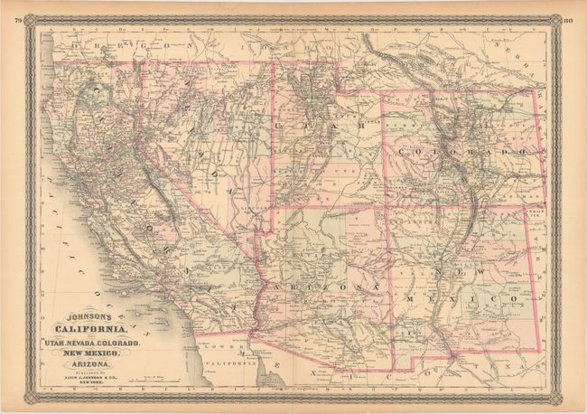
Subject: Western United States

Period: 1862-79 (circa)

Publication:

Color: Hand Color

Size:
24.4 x 16.9 inches
62 x 42.9 cm
Download High Resolution Image
(or just click on image to launch the Zoom viewer)

A. Johnson's California Territories of New Mexico and Utah, by Johnson and Ward, circa 1862. This is one of the most desirable editions from this great series of maps covering the Southwest. Arrizona shows up in the southern part of New Mexico Territory. This is thought to represent the Confederate Territory of Arizona that existed for nearly a year from August 1861 until July of 1862. The Confederate General Baylor appointed himself the territorial governor and claimed all of New Mexico Territory south of the 34th parallel. In the southern part of Arizona is the "Gadsden Ten Million Purchase of Mexico." The Utah/Nevada border is too far west on the 116th meridian. Details the Emigrant Road, the Hastings Road, and the routes of numerous explorers and military expeditions. The Gold Region in Colorado's South Park is prominently shown. The map is filled with historic and interesting notations. One note in the area of Quartzite, Arizona refers to the area as being "exceedingly fertile and abundantly timbered and well watered." Additional details include the U.S. Mail routes, the Emigrant road to California, the proposed railroad route through Utah, Nevada and California, and the Pony Express trail, the last time it appears on this series of map. Johnson was diligent in constantly revising his plates with new information. A great map of the Southwest. Condition: Light offsetting, minor foxing, and a short centerfold separation confined to the bottom blank margin that has been closed on verso with tape. There is light toning along the sheet edges.

B. Johnson's California, Also Utah, Nevada, Colorado, New Mexico, and Arizona, by A.J. Johnson, dated 1864. This is the early 1864 edition and is one of the first maps to show the original four counties in the newly organized Arizona Territory. The Utah/Nevada border is still at 115° and Arizona contains the southern tip of Nevada including the tiny settlement of Las Vegas. This is a completely new map from earlier plates with many changes in watersheds and mountain detail with several of the earlier notations removed. The Pony Express route is shown crisscrossing the proposed route of the Union Pacific while the proposed route of the Central Pacific parcels it 100 miles to the north. Details the U.S. Mail routes, the Emigrant roads to California, and numerous explorer routes. Terrific detail throughout. Condition: On a bright sheet with short centerfold separations at top and bottom that have been closed on verso with archival tape. There are light dampstains confined to the side margins.

C. Johnson's California, Also Utah, Nevada, Colorado, New Mexico, and Arizona, by Alvin J. Johnson, circa 1879. This map, copyright dated 1864 but published circa 1879, is one of the last editions in the series. It is from a completely new plate with a newly designed decorative border. It displays many changes in watershed and topography with several of the earlier notations removed and new notations inserted. Nevada has the addition of White Pine (1869), and Eureka (1873) counties, while Arizona now shows seven counties with the additions of Pinal (1875) and Apache (1879). The Pacific Railroad is shown completed through Utah, and the Pony Express route is no longer shown on the map. Condition: There are short centerfold separations at top and bottom that have been closed on verso with archival tape, and there is light toning along the top edge of the sheet.

Sizes vary slightly.

References:

Condition: B+

See description above.

Estimate: $400 - $500

Sold for: $375

Closed on 9/11/2019

Archived