Catalog Archive
Auction 174, Lot 12

Folio Set of Ortelius World and Continents

"[Lot of 5] Typus Orbis Terrarum [and] Americae sive Novi Orbis, Nova Descriptio [and] Africae Tabula Nova [and] Asiae Nova Descriptio [and] Europae", Ortelius, Abraham

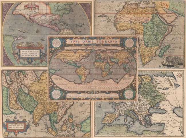
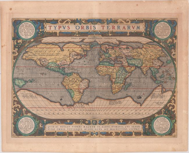
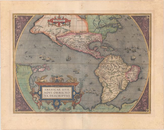
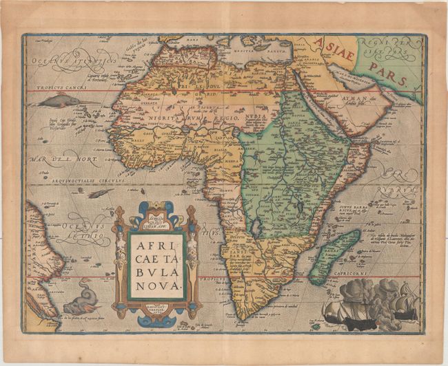
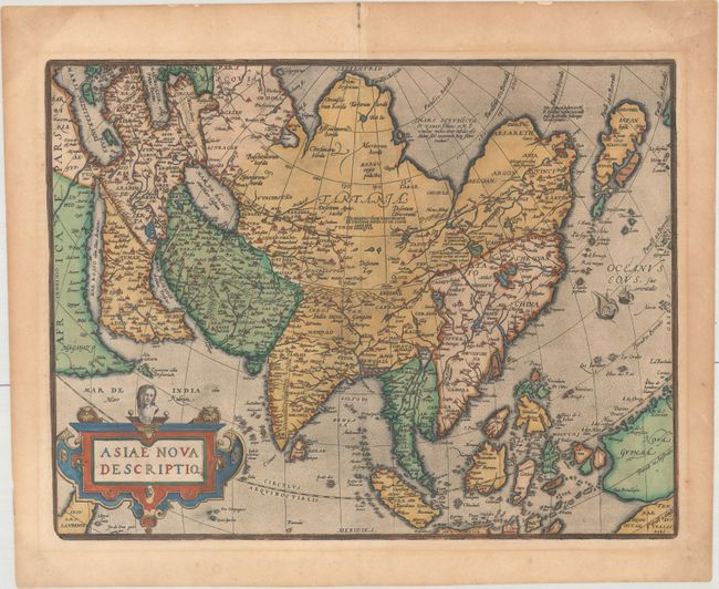
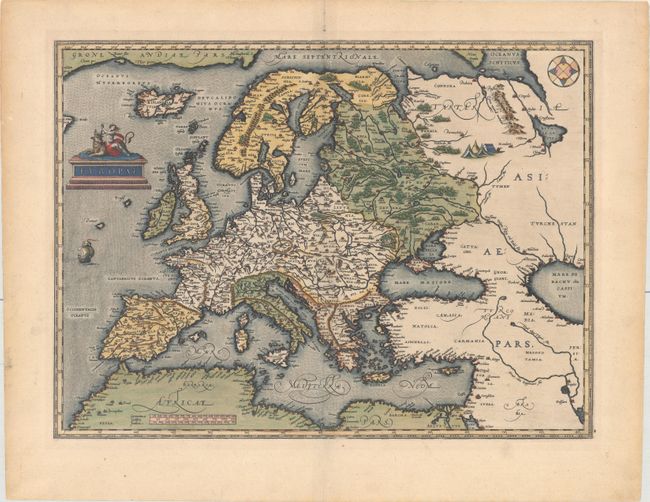
Subject: World & Continents

Period: 1570-87 (circa)

Publication: Theatrum Orbis Terrarum

Color: Hand Color

Size:
See Description
Download High Resolution Image
(or just click on image to launch the Zoom viewer)

A magnificent set of maps of the world and continents by Abraham Ortelius, published in various Latin editions of the Theatrum between 1584-1603, all with Latin text on verso. This set includes:

A. Typus Orbis Terrarum, dated 1587 (19.2 x 14.0"). Ortelius' beautiful oval world map is a simplified reduction of Mercator's influential map of 1569 presented on an oval projection rather than the projection for which Mercator is now famous. From surviving correspondence, it is known that Mercator encouraged Ortelius and provided him with information, particularly with coordinates of places in the Americas. This is the first state of Ortelius' third world map updated with the more correct shape of South America and the first depiction of the Solomon Islands off the coast of New Guinea. North America is nearly bisected by a lengthy St. Lawrence River, and the lands of Anian Regnum and Quivira are noted on the western coast. The Atlantic Ocean is filled with phantom islands, including Frieslant, St. Brandain, Brasil and many others. A huge imaginary southern continent incorporates Tierra del Fuego, and the mythical lands of Beach, Maletur and Lucach. The oval projection is surrounded by an intricate strapwork design and four corner medallions containing quotations from Cicero and Seneca. Published in 1592. Ref: Shirley #158; Van den Broecke #3.1. Condition: The common horn coat of arms watermark with light toning and a few small spots. (B+)

B. Americae sive Novi Orbis, Nova Descriptio, dated 1587 (19.0 x 13.9"). This is one of the most famous maps of America and one that had enormous influence on the future cartography of the New World. Frans Hogenberg engraved this map and it is primarily based on Gerard Mercator's great multi-sheet world map of 1569. The map features an exaggerated breadth of the North American continent, with a lengthy St. Lawrence River reaching across the continent to nearly meet the fictitious, westward flowing Tiguas Rio. The strategically placed title cartouche hides the unknown South Pacific and therefore most of the conjectural great southern continent, which is shown attached to both New Guinea and Tierra del Fuego. This is the third of the plates that Ortelius used of the Americas, evidenced by the removal of the bulge on the southwestern coast of South America and an added cartouche in North America. Also on this plate, the Solomon Islands are noted for the first time since their discovery in 1568, and the names California, R. de los estrechos, and C. Mendocino have been added to the west coast of North America. The native name of Wingandekoa has been added to the eastern coast, originating from an unsuccessful attempt to colonize the Outer Banks by the English. Published in 1595. Ref: Burden #64; Van den Broecke #11.1. Condition: The common crossed arrows watermark with contemporary color and very minor toning. (A)

C. Africae Tabula Nova, dated 1570 (19.8 x 14.8"). This striking map is one of the cornerstone maps of Africa and remained the standard map of Africa well into the seventeenth century. It was designed by Ortelius from elements of contemporary maps by Gastaldi, Mercator, and Forlani and used several recent sources: Ramusio in Navigationi et Viaggi (1550), Joao de Barros in Decadas da Asia (1552), and Leo Africanus in Historiale description de l'Afrique (1556). The majority of the nomenclature is taken from Gastaldi. The Nile is based on the Ptolemaic concept, originating from two large lakes south of the equator. Curiously Ortelius did not represent the Mountains of the Moon (a prominent feature on most prior maps) and the twin lakes are not named. Ortelius introduced two important changes to the shape of the continent on this map; the Cape of Good Hope is more pointed, and the eastward extension of the continent was reduced significantly. The map is decorated with a strapwork title cartouche, a grand sea battle (copied from Diego Gutierez' wall map of the Americas), and sea monsters. This beautiful map was engraved by Frans Hogenberg who engraved many of the maps for the Theatrum. This is the fifth state, published in 1603. Betz #12.5; Van de Broecke #8.5; Norwich #10. Condition: The common horn coat of arms watermark with light toning that is more prominent in the blank margins and a few small spots. (B+)

D. Asiae Nova Descriptio, (19.1 x 14.6"). Ortelius' great map of Asia was based on his wall map of 1567, which was in turn based on the work of Gastaldi and various other sources. This map was the standard map of Asia for more than forty years. The cordiform projection shows Asia extended too far to the east, an error propagated with Ptolemy. Japan is in a 'kite' form taken from Jesuit sources. Luzon is absent from the Philippines and the mythical lake Cayamay lacus is located in southern China. There are a great number of islands in the East Indies, but not well placed, due to the secrecy of voyages to the region. The title is emblazoned onto a large strapwork cartouche. This is the second, re-engraved plate, published in 1603. Ref: Van den Broecke #7; Walter #11-C; Yeo #5. Condition: The common horn coat of arms watermark with light toning that is more prominent in the blank margins and a few small spots. (B+)

E. Europae, (18.2 x 13.4"). This handsome map was based on Gerard Mercator's 1554 map of Europe and incorporates Magnus' information on Scandinavia and Jenkinson's map for Russia. The map extends to include Iceland and part of Greenland, and there is a tiny bit of Labrador intruding into the map at upper left. It also extends into western Asia and Northern Africa based on Gastaldi's cartography. Finely engraved with a stippled sea and modestly adorned with a sailing ship, compass rose, and a tent encampment in Russia. The personification of Europa being abducted by Zeus in the form a bull graces the title cartouche. This is the second, re-engraved plate, published in 1584. Ref: Van den Broecke #5. Condition: A coat of arms watermark on a bright sheet with two tiny holes in the image. Two previous owner's stamps on verso have been marked over with ink. (A)

References:

Condition:

Each of the maps has small remnants of hinge tape on verso. See description above for additional details.

Estimate: $14,000 - $17,000

Sold for: $11,500

Closed on 9/11/2019

Archived