Catalog Archive
Auction 173, Lot 62

The Second Printed Map of the North American Continent

"Americae Pars Borealis, Florida, Baccalaos, Canada, Corterealis", Jode, Cornelis de

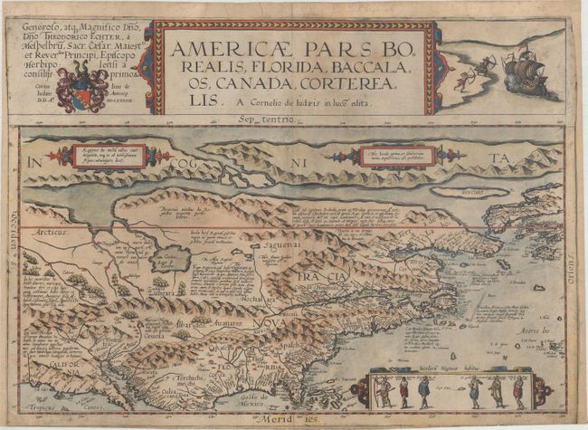
Subject: North America

Period: 1593 (dated)

Publication: Speculum Orbis Terrae

Color: Hand Color

Size:
19.8 x 14.1 inches
50.3 x 35.8 cm
Download High Resolution Image
(or just click on image to launch the Zoom viewer)

This very rare map is the second printed map of the North American continent, following the smaller Forlani map of 1565. It was issued in Cornelis de Jode's Speculum Orbis Terrae in 1593, which was a revised edition of an earlier atlas published by his father Gerard in 1578. The present map was one of the several new engravings in Cornelis' work. While the atlas did not have much commercial success, de Jode's maps are often regarded as superior in both design and cartographic detail to his more successful competitor, Abraham Ortelius.

Cartographically, the map is based upon Petrus Plancius' eighteen sheet world map of 1592 for the outline of North America. With only a few exceptions, the place names also directly follow Plancius' work. The map is notable for incorporating some of the concepts published in Theodore de Bry's Grand Voyages from 1590, including maps by John White and Jacques Le Moyne. Despite this new information, the Chesapeake Bay is placed too far north at a latitude equivalent to present-day Boston, while Virginia is north of C. de las Arenas (Cape Cod). These misplacements pushed the entire coastline too far to the north, and Norombega (New England) extends in an east-west direction between Chesepoc Sinus and the St. Lawrence River. To the north of the North American landmass is a prominent depiction of a Northwest Passage with a large mythical Lago de Conibas emptying into it. In the southwest, the seven cities of Cibola are situated next to an unnamed lake along with a note about Marcus Niza. The map is beautifully embellished with de Jode's distinct style, and is further decorated by a cartouche featuring six Virginia natives (per John White) and a vignette depicting the attack on Martin Frobisher's ship. Dedication to Theodor Echter at top left.

There was only one edition of the Speculum produced, making this map quite rare on the market. The present example has a blank verso, and Burden notes that de Jode was selling this map both in the atlas and as a separate sheet. Wagner also states that examples occur without text.

References: Burden #81; Cumming (SE) #16; Wagner (NW) #169; Wheat (TMW) #25; Schwartz & Ehrenberg plt. 39.

Condition: B+

Issued on watermarked paper that has been trimmed to the neatline at bottom (slightly inside the neatline at far right). The sheet has been professionally backed with tissue to reinforce and repair a 2" horizontal tear near "Terra Corterealis" and a 1" tear perpendicular to the centerfold just above "Apalche." A minor centerfold separation at bottom and a few edge tears confined to the top blank margin have all been archivally repaired on verso. Minor surface soiling.

Estimate: $36,000 - $45,000

Sold for: $23,000

Closed on 6/5/2019

Archived