Catalog Archive
Auction 171, Lot 736

First Chart of the East Coast of Australia

"A Chart of New South Wales, or the East Coast of New-Holland. Discover'd and Explored by Lieutenant J. Cook, Commander of His Majesty's Bark Endeavour, in the Year MDCCLXX", Cook, James (Capt.)

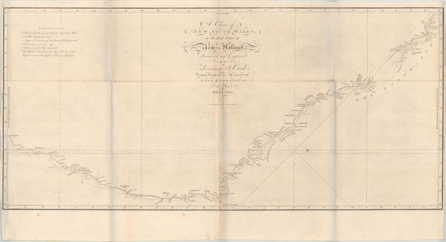
Subject: Eastern Australia

Period: 1773 (published)

Publication: Account of the Voyages Undertaken...in the Southern Hemisphere

Color: Black & White

Size:
30.9 x 14.3 inches
78.5 x 36.3 cm
Download High Resolution Image
(or just click on image to launch the Zoom viewer)

This is the first published chart of the east coast of Australia from Captain James Cook's first Pacific voyage in 1768-71. The map shows the routes of the Endeavor with names bestowed by Cook, including Botany Bay, which was named for the large quantities of plants located there. The chart is oriented with north to the right by a delicate fleur-de-lis and soundings are located along the route. Engraved by W. Whitchurch and published by John Hawkesworth in his Account of the Voyages Undertaken...in the Southern Hemisphere, which details the explorations of Commodore Byron, Captain Wallis, Captain Carteret, and Captain Cook.

References: Tooley (Australia) #325; Shirley (BL Atlases) G.HAWK-1a #26.

Condition: B+

Issued folding on watermarked paper with light offsetting, faint scattered foxing, and light toning along the middle fold. Side margins are narrow, but still adequate for framing. (The bluish hue along the fold lines in the image is caused by our scanner and is not on the physical map.)

Estimate: $1,400 - $1,700

Sold for: $800

Closed on 2/6/2019

Archived