Catalog Archive
Auction 171, Lot 735

NO RESERVE - The Earliest Chart of the Coast of Queensland

"Chart of Part of the Coast of New South Wales, from Cape Tribulation to Endeavour Straits", Cook, James (Capt.)

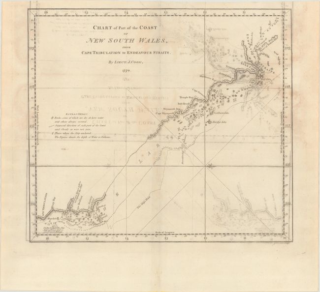
Subject: Northeastern Australia

Period: 1773 (published)

Publication: Account of the Voyages Undertaken...in the Southern Hemisphere

Color: Black & White

Size:
13.3 x 11.8 inches
33.8 x 30 cm
Download High Resolution Image
(or just click on image to launch the Zoom viewer)

This map outlines the eastern shore of Cape York from Cape Tribulation to the Endeavour Strait at the northern tip. The track of Captain Cook's first voyage to the South Pacific is shown. The anchorages of the Endeavour are depicted, along with rocks, shoals, and soundings. A notation near Cape Tribulation identifies where the ship "laid 23 hours, and received much damage." A fleur-de-lis orients north to the right. Engraved by J. Cheevers and published by John Hawkesworth in his Account of the Voyages Undertaken...in the Southern Hemisphere, which details the explorations of Commodore Byron, Captain Wallis, Captain Carteret, and Captain Cook.

References: Tooley (Australia) #327; Shirley (BL Atlases) G.HAWK-1a #27.

Condition: B

Issued folding on watermarked paper with moderate offsetting and light dampstains.

Estimate: $300 - $400

Sold for: $85

Closed on 2/6/2019

Archived