Catalog Archive
Auction 169, Lot 140

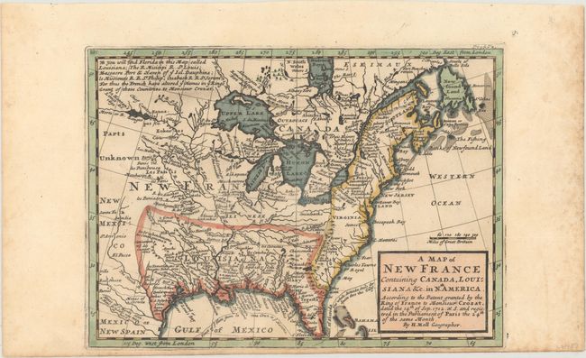
"A Map of New France Containing Canada, Louisiana &c. in Nth. America. According to the Patent Granted by the King of France to Monsieur Crozat...", Moll, Herman

Subject: Colonial Eastern United States & Canada

Period: 1717 (circa)

Publication:

Color: Hand Color

Size:
10.1 x 7.3 inches
25.7 x 18.5 cm
Download High Resolution Image
(or just click on image to launch the Zoom viewer)

This interesting map depicts the French possessions in North America in the early part of the eighteenth century. New France included Canada and the proprietary colony of Louisiana, which included the former Spanish possessions in Florida. In 1712, King Louis XIV selected Antoine Crozat, the Marquis de Chatel, as the proprietor for Louisiana. Crozat was granted a monopoly on trade for fifteen years, but failed to develop the colony and relinquished his rights in 1717. The map is filled with information including colonial settlements, Indian villages, and forts. The British colonies are confined east of the Appalachian Mountains. The Great Lakes are presented in a strange format and La Hontan's R. Longue is shown in the upper left. The route of the Spanish treasure fleet is shown in the Gulf of Mexico and around the tip of Florida.

References: McCorkle #717.1.

Condition: A

A nice impression with minor foxing confined to the blank margins.

Estimate: $475 - $600

Sold for: $400

Closed on 9/12/2018

Archived