Catalog Archive
Auction 168, Lot 90

Two-Sheet Map Showing the Island of California - First State

"Amerique Septentrionale Divisee en ses Principales Parties, ou sont Distingues les uns des Autres les Estats...", Sanson/Mortier

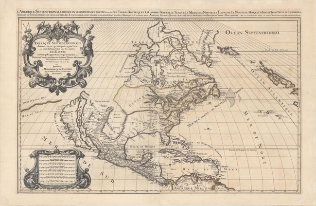
Subject: Colonial North America

Period: 1692 (dated)

Publication: Atlas Nouveau

Color: Hand Color

Size:
34.1 x 21.2 inches
86.6 x 53.8 cm
Download High Resolution Image
(or just click on image to launch the Zoom viewer)

This beautiful map of the Americas shows California as an island in the style of the second Sanson model (1656) with the indented northern coastline. A small peninsula Agubela de Gato is the only part of the Pacific coastline shown north of California. A strip of Terre de Iesso, ou Ieco is shown in the Pacific immediately west of northern California. Santa Fe is shown along the R. del Norte (Rio Grande River), but the river erroneously drains into the Gulf of California. The two western Great Lakes are open-ended, and Lake Erie is too far south, split by the 40th parallel. The eastern part of the continent is divided into Canada ou Nouvelle France and Floride with Virginia, New Sweden, New Amsterdam, and New England hugging the coast. The decorative title cartouche is adorned with the arms of the Dauphine, two natives, and tropical birds. This is Mortier's edition of Jaillot's map, in which Mortier purposely omitted his imprint and indicated the map was published in Paris (despite having been engraved and printed in Amsterdam) in order to capitalize on the popularity of Jaillot's Atlas Nouveau. First state, dated 1692. Printed on two sheets, joined.

References: Burden #686; cf. McLaughlin #55; cf. Wheat (TMW) #58; McCorkle #692.4.

Condition: B+

A dark impression with original outline color. There is light offsetting and an expertly repaired edge tear that enters 6" into the image at left. A 4.5" centerfold separation at bottom has also been professionally repaired on verso.

Estimate: $2,400 - $3,000

Sold for: $1,800

Closed on 6/6/2018

Archived