Catalog Archive
Auction 168, Lot 37

Map of the Ancient World with Depictions of the Four Elements

"Universalis Tabula Iuxta Ptolemaeum", Ptolemy/Mercator

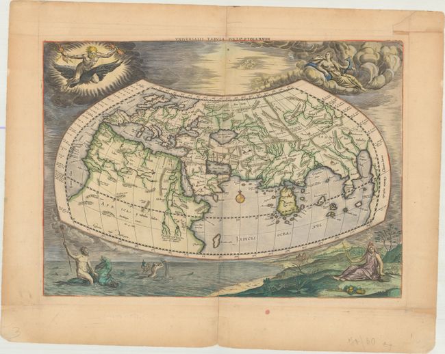
Subject: Ancient World

Period: 1730 (circa)

Publication: Claudii Ptolemaei's Atlas Tabulae Geographicae Orbis Terrarum

Color: Hand Color

Size:
18.7 x 13.4 inches
47.5 x 34 cm
Download High Resolution Image
(or just click on image to launch the Zoom viewer)

Claudius Ptolemy was a mathematician, astronomer and geographer who worked in Alexandria, then a part of the Roman Empire, in the 2nd century AD. One of the most learned and influential men of his time, his theories dominated both astronomy and geography for nearly 1500 years. His writings were kept alive by Arabic scholars during the Middle Ages and reemerged in Europe during the Renaissance. The birth of printing led to wide dissemination of his great works on astronomy and geography. There were a number of editions of his Geographia beginning in 1477. These early editions contained maps based on his original writings, known as Ptolemaic maps. As geographic knowledge increased with the explorations of Columbus, Magellan, Cabot and others, maps of the New World were added, and maps of the Old World were revised. Ptolemy's Geographia continued to be revised and published by some of the most important cartographers including Martin Waldseemuller, Sebastian Munster, Giacomo Gastaldi, Jodocus Hondius, and Gerard Mercator (whose last edition was published in 1730).

This decorative map of the ancient world is the revised second state of Mercator's 1578 Ptolemaic world map. The border was re-engraved, surrounded by allegorical figures representing the four elements of Fire (Zeus), Air (Hera), Water (Neptune), and Earth (Gaia), rather than the strapwork and wind head border of the earlier edition. There is a very large Taprobana (modern day Sri Lanka) in the Indian Ocean and the Indian subcontinent is severely truncated, though the Ganges is noted. Only the northern part of Africa is shown with the Nile originating in the twin lakes south of the Equator in the Lunae montes (Mountains of the Moon). Blank verso.

References: cf. Shirley #139; Van der Krogt (Vol. I) #0900:1.2; Mickwitz & Miekkavaara #235-1.

Condition: B+

There are archivally repaired centerfold separations at top and bottom, with the bottom separation extending 0.75" into the image. There are several other edge chips and tears confined to the blank margins that have also been closed on verso with archival materials.

Estimate: $1,800 - $2,100

Sold for: $1,300

Closed on 6/6/2018

Archived