Catalog Archive
Auction 168, Lot 337

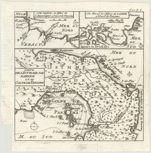
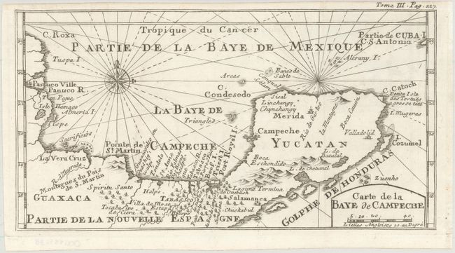
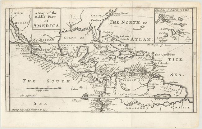
"[Lot of 3] Carte de l Isthme de Darien et du Golfe de Panama [and] Carte de la Baye de Campeche [and] A Map of the Middle Part of America", Dampier, William (Capt.)

Subject: Central America, Gulf of Mexico

Period: 1715-29 (circa)

Publication: A New Voyage Round the World

Color: Black & White

Size:
See Description
Download High Resolution Image
(or just click on image to launch the Zoom viewer)

William Dampier (baptized 1651-1715) was a buccaneer (pirate) and sea captain. He was the first Englishman to explore parts of New Holland and New Guinea, and was the first man to circumnavigate the world three times.
In the 1670s he crewed with buccaneers on the Spanish Main of Central America, which eventually led to his first circumnavigation. On the ship Cygnet, following Pacific-spanning raids that included the East Indies, Manila, and the Spice Islands, Dampier's ship was beached on the northwest coast of Australia in 1688. Waiting for repairs, his scientific interest surfaced as he made notes and drawings on the local fauna and flora. Following three years of further adventures he returned to England. In 1697 he published his experiences in A New Voyage. Described as one of the greatest tales of adventure and exploration ever written, the book was published in several languages. It is reported that Captain Cook used Dampier's nautical observations on his voyages, and Charles Darwin found his books so useful that he took them aboard the Beagle.

A. Carte de l'Isthme de Darien et du Golfe de Panama, circa 1715 (6.1 x 6.1"). This uncommon chart shows the activities of William Dampier and his fellow buccaneers in Central America. It depicts the route of their raid across the inhospitable Isthmus of Darien to the Gulf of Panama where they captured Spanish ships and raided Spanish settlements. Locates Panama [City], Portobello, and several villages. At the top of the chart are two insets: Cote Septentr. De l'Isthme de l'Amerique a l'Ouest de Panama; and Cote Merid de l'Isthme de l'Amerique a l'Ouest de Panama. From the 1715 French edition. Reference: Kapp (Panama) #39.

B. Carte de la Baye de Campeche, circa 1715 (10.8 x 5.6"). This map of Mexico covers the region from Tampico east to Campeche and Cancun. Detail is limited primarily to coastal place names, several rivers, and mountains in profile. Decorated by a compass rose capped by a fleur-de-lis and rhumb lines. From the 1715 French edition.

C. A Map of the Middle Part of America, circa 1729 (11.2 x 6.1"). This chart shows part of the route of Dampier's first circumnavigation voyage in the 1680s with his passage across the isthmus of Panama. The map covers the area of northern South America through Central America into what is now the southern United States with Maryland, Virginia, Carolina, Florida, and New Mexico named. There is an inset map detailing the Cape Verde islands with the route of exploration delineated. On the map, California is an island although only the southern portion is shown. From the 1729 English edition.

References:

Condition: A

Dark impressions on clean sheets. Issued folding.

Estimate: $350 - $425

Sold for: $180

Closed on 6/6/2018

Archived