Catalog Archive
Auction 168, Lot 263

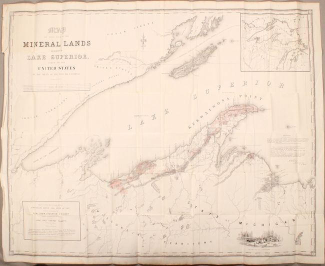
"Map of That Part of Mineral Lands Adjacent to Lake Superior, Ceded to the United States by the Treaty of 1842 with the Chippewas [with report]", U.S. Government

Subject: Michigan & Wisconsin

Period: 1846 (published)

Publication: H.R. Doc. 211, 29th Congress, 1st Session

Color: Hand Color

Size:
45.3 x 35.6 inches
115.1 x 90.4 cm
Download High Resolution Image
(or just click on image to launch the Zoom viewer)

This uncommon, early report describes the mineral wealth of the Lake Superior district in glowing terms, describing the region as having "metallic veins and deposites [sic] of extraordinary magnitude and richness." Written by Andrew Gray, this 23 page report is accompanied by a very large map of the region that was under the superintendency of Gen. John Stockton. The map was compiled partly from explorations made in 1844 by the Mineral Lands Agency at Copper Harbor, partly from a map published by S.D.U.K., and drawings from U.S. Surveys by Dr. Houghton, W.A. Burt, Nicollet & Bayfield. Mineral tracts are located and numbered, with leased tracts indicated by hand coloring. It shows the trap range of northern Michigan, locations of the American Fur Company Posts, and Catholic/Methodist Missions. Includes a large inset map of Lake Superior at top right, and an engraved view of Camp Gray near Talcott Harbor at bottom. This octavo report appears to have been separately issued and not disbound from a larger Congressional volume.

References:

Condition: A

Condition code is for the map which is mostly clean and bright with an occasional spot of foxing, a few tiny splits at fold intersections, and minor extraneous creasing at left. Report text is very good with minor foxing.

Estimate: $700 - $850

Sold for: $350

Closed on 6/6/2018

Archived