Catalog Archive
Auction 168, Lot 167

Important British Map at the Outbreak of the American Revolution

"A General Map of the Middle British Colonies, in America. Containing Virginia, Maryland, the Delaware Counties, Pennsylvania and New Jersey. With the Addition of New York...", Sayer & Bennett

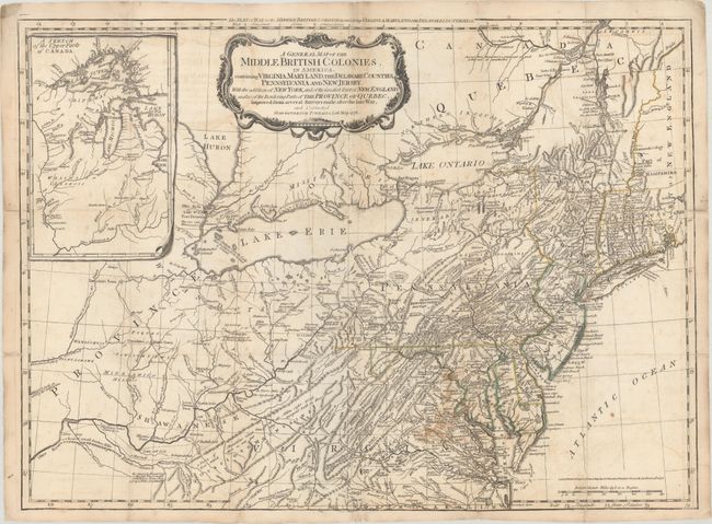
Subject: Colonial Mid-Atlantic United States

Period: 1776 (dated)

Publication: American Military Pocket Atlas

Color: Hand Color

Size:
26.1 x 19.2 inches
66.3 x 48.8 cm
Download High Resolution Image
(or just click on image to launch the Zoom viewer)

This is a later derivative of the seminal Lewis Evans map of the Middle British Colonies, which was one of the landmarks of American cartography. It has been updated to illustrate the Seat of War at the outbreak of the American Revolution from Governor Pownall's map of the same year. The map covers the region from Montreal and the lower end of Lake Huron to the North Carolina border, and from the Falls of the Ohio to Narragansett Bay, with an inset Sketch of the Upper Parts of Canada (Illinois Country). This map was an invaluable resource during the war and is filled with incredibly detailed information including provincial boundaries, courthouses, roads, trails, Indian villages and territories, forts, swamps, mines, portages, and distances between towns. Sayer and Bennett's imprint and the date, 15th Oct. 1776, just above the distance scale.

References: McCorkle #776.10; Sellers & Van Ee #714; Steven & Tree #30-g.

Condition: B

Issued folding on watermarked paper. There is light offsetting, minor foxing, and a bit of staining in Virginia. A number of fold separations have been repaired on verso with archival materials.

Estimate: $4,000 - $4,750

Unsold

Closed on 6/6/2018

Archived