Catalog Archive
Auction 168, Lot 158

Rare Civil War Railroad Map

"Lloyd's American Railroad Map, Showing the Whole Seat of War", Lloyd, James T.

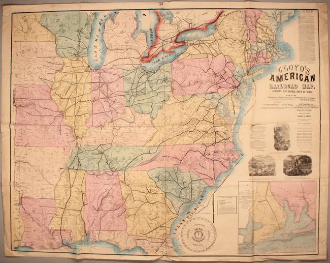
Subject: Eastern United States, Civil War

Period: 1861 (dated)

Publication:

Color: Hand Color

Size:
47.6 x 37.3 inches
120.9 x 94.7 cm
Download High Resolution Image
(or just click on image to launch the Zoom viewer)

This rare map was issued only six months after the beginning of the American Civil War. It was printed on the back of "Lloyd's American Railway Weekly," October 5, 1861, which was considered the definitive reference at the time for the railway system east of the Mississippi. Drawn on a scale of 30 miles per inch it presents an amazing amount of detail including railroad stations, towns and villages, watershed, topography and more. The map extends westward to show a small portion of Texas, north to above Augusta, Maine and south to include the Florida panhandle in its entirety. The large fully colored inset "Escambia, Santa Rosa Cos. FL. Showing Pensacola Harbor" (12" x 11") details the vicinity of Pensacola showing Fort Pickens, Fort McRae, Bragg's Batteries and the U.S. Fleet in the harbor. A large vignette "Lloyd's American Weekly Time Dial" explains the time in 28 cities across the U.S. The verso contains "Historical and Descriptive Sketch of All Places of Interest in the Southern States", an extensive railroad schedule providing times for hundreds of trains, and advertisements filling the balance. This map was first published in the June 15, 1861 issue of Lloyd's weekly newspaper (see references).

References: cf. Modelski #43; cf. Stephenson #14.

Condition: B

Issued folding with light scattered foxing and a few short splits at fold intersections. There are a number of misfolds and several tiny edge tears that have been closed on verso with archival tape. A nice example considering the medium.

Estimate: $700 - $900

Sold for: $500

Closed on 6/6/2018

Archived