Catalog Archive
Auction 167, Lot 129

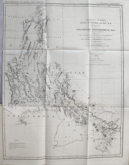
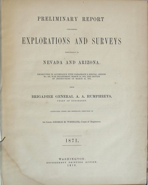
"Preliminary Topographical Map Embracing in Skeleton a Portion Only of the Notes from Surveys... [bound in] Preliminary Report Concerning Explorations and Surveys Principally in Nevada and Arizona...", Wheeler, George (Lt)

Subject: Southwestern United States

Period: 1872 (published)

Publication:

Color: Black & White

Size:
22.1 x 28.3 inches
56.1 x 71.9 cm
Download High Resolution Image
(or just click on image to launch the Zoom viewer)

The 1870s was a period of intense effort, by such prominent people as Clarence King, Ferdinand Hayden, and John Wesley Powell, to advance the geographical knowledge of the West. These various surveys presented a threat to the Army's supremacy in the field of mapping and to the related appropriations from Congress. As a result of these pressures, the Army Corp of Engineers developed a plan to systematically survey the entire West to be called the U.S. Geographical Surveys West of the One Hundredth Meridian. The region was divided up into 95 rectangles, with atlas sheets to be prepared for each, comprising an area 2°45' of longitude and 1°40' of latitude on a scale of eight miles to the inch. Lieutenant George Wheeler was chosen to head this immense project. Surveys were conducted each summer from 1872 to 1878, after which Congress cut off appropriations for field work; thus the survey was not completed as originally envisioned. Wheeler published annual reports from 1873 to 1884, as well as the final Geographical Report published in 1889. The maps from this report are a valuable document of the record of Western exploration.

This complete report describes Wheeler's explorations in Nevada and Arizona and the first exploration of Death Valley. It is complete with the large folding Preliminary Topographical Map that covers parts of Southern California, Nevada and Arizona and details scores of mining districts. Wheat refers to it as a "map of great interest." Wheeler was modest regarding the map's construction and in the notations said the map "is a hasty and partial compilation from the topographical data already received, many still remaining en route." The report contains a great amount of information on the mining districts, as well as information concerning the Indians, military sites, routes for roads, and grazing lands. Quarto, 96 pp., original gilt-titled maroon cloth covers. This copy also includes a printed label on the front pastedown stating "Compliments of Geo. M. Wheeler." The map was also published in Senate Doc. #65, 42nd Congress, 2nd Session, but this preliminary report is scarce, more so complete with the map.

This map is labeled preliminary, as it was the forerunner of what would become one of the most important surveys of the American West. The 1870s was a period of intense effort, by such prominent people as Clarence King, Ferdinand Hayden, and John Wesley Powell, to advance the geographical knowledge of the West. These various surveys presented a threat to the Army's supremacy in the field of mapping and to the related appropriations from Congress. As a result of these pressures, the Army Corp of Engineers developed a plan to systematically survey the entire West which became the U.S. Geographical Surveys West of the One Hundredth Meridian. Lieutenant George Wheeler was chosen to head this immense project largely as a result of the surveys he conducted in Nevada and Arizona.

References: Howes #W321; Wheat (TMW) #1237.

Condition: B+

The map has faint offsetting and a 3" binding tear at left. Text is lightly toned with a damp stain in the lower gutter and a pair of worm tracks also in the gutter in the first 15 pages of text. Covers are stained with bumped edges.

Estimate: $200 - $250

Sold for: $100

Closed on 3/28/2018

Archived