Catalog Archive
Auction 166, Lot 671

First Printed Map to Focus on Indochina and the East Indies

"Tabula Nova Indiae Orientalis & Meridionalis", Ptolemy/Fries

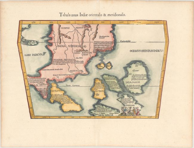
Subject: Southeast Asia

Period: 1541 (published)

Publication: Claudii Ptolemaei Alexandrini Geographicae…

Color: Hand Color

Size:
16.9 x 11 inches
42.9 x 27.9 cm
Download High Resolution Image
(or just click on image to launch the Zoom viewer)

Claudius Ptolemy was a mathematician, astronomer and geographer who worked in Alexandria, then a part of the Roman Empire, in the 2nd century AD. One of the most learned and influential men of his time, his theories dominated both astronomy and geography for nearly 1500 years. His writings were kept alive by Arabic scholars during the Middle Ages and reemerged in Europe during the Renaissance. The birth of printing led to wide dissemination of his great works on astronomy and geography. There were a number of editions of his Geographia beginning in 1477. These early editions contained maps based on his original writings, known as Ptolemaic maps. As geographic knowledge increased with the explorations of Columbus, Magellan, Cabot and others, maps of the New World were added, and maps of the Old World were revised. Ptolemy's Geographia continued to be revised and published by some of the most important cartographers including Martin Waldseemuller, Sebastian Munster, Giacomo Gastaldi, Jodocus Hondius, and Gerard Mercator (whose last edition was published in 1730).

This scarce map is a landmark in the cartography of Southeast Asia - the first printed map to focus on the region of Malaya, Indochina and the East Indies. It was based on Waldseemuller's large 1507 cordiform world map, which was in turn taken from the Martellus model with nomenclature derived principally from Marco Polo. The mythical Lake Chiang Mai, labeled Lamia Lacq, is located at the top border. The islands are placed in a barely recognizable fashion including Iava Maior in roughly the position of Borneo. The map's nomenclature is derived principally from Marco Polo. A small vignette illustrating cannibalism is set in the island of Angama (Andaman Islands), which is totally misplaced to the east of Java. This map was one of three new maps that Fries had engraved for his editions of Ptoelmy's Geographia that were not reduced versions of Waldseemuller's maps. This map first appeared in the 1522 edition of Fries' Claudii Ptolemaei Geographicae.... Blank verso.

This edition was printed by Gaspar Treschel and edited by Michael Villanovus (known as Servetus). Servetus was charged with heresy by John Calvin in 1553, in part due to the text in this atlas. The courts found him guilty and sentenced him to burning at the stake, atop a pyre of his own books, including this atlas.

References: Mickwitz & Miekkavaara #211-42; Suarez (Sea) Fig 62, pp.114-118.

Condition: A

A nice impression on a clean, bright sheet with expert repairs to a few tiny separations along the centerfold and to two small worm holes - one in an unengraved area of the map at top center and the other just above the top neatline. There is light toning along the edges of the sheet.

Estimate: $2,200 - $2,500

Sold for: $2,300

Closed on 2/14/2018

Archived