Catalog Archive
Auction 166, Lot 393

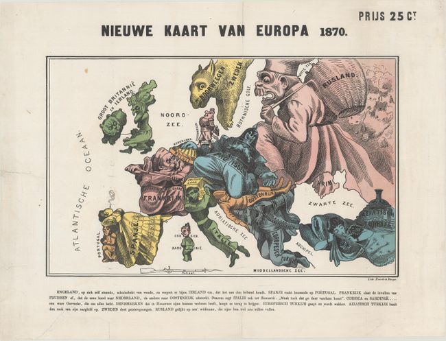
Satirical Map at the Outset of the Franco-Prussian War

"Nieuwe Kaart van Europa 1870", Emrik & Binger

Subject: Europe

Period: 1870 (dated)

Publication:

Color: Printed Color

Size:
15.2 x 9.6 inches
38.6 x 24.4 cm
Download High Resolution Image
(or just click on image to launch the Zoom viewer)

This rare satirical map was originally created by Paul Hadol, a French illustrator and caricaturist, at the outset of the Franco-Prussian War. This popular map was republished in several different languages and distributed throughout Europe. This example was published in Denmark by Emil Olsens Lithography. Various countries and regions are represented by human and animal caricatures with props to help illustrate the situation. Danish text below the map describes each country's "character."

At the center of the conflict are France and Prussia, with France depicted as an old man using his sword to thwart the advances of Prussia. Prussia appears as a stocky Otto von Bismarck with his hat pulled over his eyes and kneeling on Austria, a sleeping soldier, while his right hand completely covers Holland. England is shown as an enraged old woman walking her dog (Ireland) and turning her back on Europe. The Balkans are represented by a man who is yawning and just beginning to awake. A Spanish senorita naps on a kneeling Portugal, while Turkey, in the guise of a harem girl smokes a hookah. The figure of Garibaldi represents Italy, his head and shoulders protected from Prussian encroachment by the shelter of a Swiss roof. Norway and Sweden take the form of a sheep. Russia is depicted as the bogey-man, trying to fill up his basket (with shadowy bear-like figures behind him).

Although the human personification of continents and countries can be seen as early as the 14th century (on maps by Opicinus de Canestris), human and animal metaphors on maps reached a new level in Europe between 1845 and 1945 with political cartoon maps. The rise of these satirical maps reflected the momentous political and cultural changes that occurred during the time. Political leaders were caricaturized and European nations were given symbolic identities that lent humor and accessibility to the geographical map. Based on popular stereotypes, these visual representations even found their way into the classroom to help bring geography and politics to life. Original serio-comic maps are very scarce due to their ephemeral nature.

References: cf. Tooley (MCC-1) #75-79.

Condition: B+

A bright example with some extraneous creases that have been pressed flat, a faint damp stain in the Atlantic, and professional repairs to some short tears, mostly along the folds.

Estimate: $900 - $1,100

Sold for: $750

Closed on 2/14/2018

Archived