Catalog Archive
Auction 165, Lot 79

Features the Republic of Texas with Washington as Capital

"Map of the Western & Middle Portions of North America, to Illustrate the History of California, Oregon, and the Other Countries on the North-west Coast of America", Greenhow, Robert

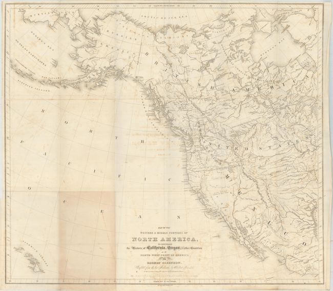
Subject: Western North America, Texas

Period: 1844 (published)

Publication: The History of Oregon and California and other Territories of the North-West…

Color: Black & White

Size:
25.8 x 22.9 inches
65.5 x 58.2 cm
Download High Resolution Image
(or just click on image to launch the Zoom viewer)

This copper engraved map shows the western part of North America, extending to Acapulco in the south and Alaska to the north including the Bering Strait and a small portion of Russian Asia. The Sandwich Islands are at lower left. Canada is named British America with the region west and south of Hudson Bay called Hudson's Bay Company's Territories. The Red River Settlements are clearly shown south of Winnipeg Lake. The western half of the United States is shown with no states or territories individually named.

The Independent Republic of Texas, names S. Antonio de Bexar and Austin. Washington is shown as the capital; in 1836-37 five towns served as temporary capitals for the newly formed republic: Washington-on-the-Brazos, Harrisburg, Galveston, Velasco and Columbia. The Texas Declaration of Independence was enacted at Washington-on-the-Brazos on March 2, 1836, making it a logical choice for the first capital, a designation seen on few maps.

The Great Basin is a large Sandy Plains Containing Salt Lakes & Swamps with no rivers or other features. According to Wheat, Greenhow included some early information from Fremont's explorations. Greenhow was a strong advocate of American expansion into the Northwest, so it is not surprising this map shows the Oregon Region extending well into Canada, a nod to the border dispute characterized by the famous "Fifty-four Forty or Fight" slogan. Drawn by George H. Ringgold and engraved by E.F. Woodward, both of Philadelphia. A most uncommon issue.

References: Wheat (TMW) #481.

Condition: B

Issued folding with light offsetting and a small section of light toning at bottom where the map folded into the book.

Estimate: $275 - $350

Sold for: $150

Closed on 11/15/2017

Archived