Catalog Archive
Auction 165, Lot 727

Rare First Edition Showing the Northwest Coast of North America and an Elongated Hokkaido

"Carta Particolare della Parte Orientale del' Isola di Iezo con li Stretto fra America e la detta Isola ... d'Asia Carta XVIII", Dudley, Robert (Sir)

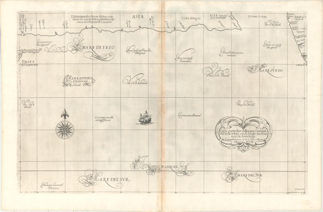
Subject: North Pacific Ocean

Period: 1647 (published)

Publication: Dell' Arcano del Mare

Color: Black & White

Size:
29.8 x 18.7 inches
75.7 x 47.5 cm
Download High Resolution Image
(or just click on image to launch the Zoom viewer)

This is the very rare, first edition of Dudley's map of the northern Pacific Ocean. The map shows the southern coast of the island of Hokkaido (Iezo) along the top of the sheet, which extends nearly all the way to the northwest coast of North America at top right. This common cartographic error was based on the reports of Girolamo de Angelis, a Jesuit who traveled to Hokkaido and miscalculated the length of the island. The northeastern tip of Honshu is shown at far left. Iezo is separated from the North American coast by the Strait of Ezo (Il Stretto di Iezo). There are a number of place names in North America, including Quivira and C. Mendosino. The distinctive calligraphy (alla cancellaresca), fine cartouche, compass rose and sailing ship are the work of the engraver, Antonio Francesco Lucini. Printed on two, joined sheets as issued.

Robert Dudley was the first Englishman to produce a sea atlas, Dell Arcano del Mare (Secrets of the Sea). He introduced a totally new style for sea charts in the atlas with only lines of latitude and longitude and no rhumb lines. The charts were meticulously compiled from original sources and were both scientific and accurate for the time. This important atlas was the first sea atlas of the whole world; the first to use Mercator's projection throughout; the earliest to show the prevailing winds, currents and magnetic deviation; and the first to expound the advantages of Great Circle Sailing. In an introductory leaf found in one copy in the British Library, the engraver states that he worked on the plates in seclusion for twelve years in an obscure Tuscan village, using no less than 5,000 pounds of copper for the printing plates. It was only issued in two editions and the maps are rarely seen on the market. This map is from the first edition.

References: cf. Burden #284; cf. Hubbard #22; Shirley (BL Atlases) M.DUD-1a #108; Walter #111.

Condition: B

A dark impression on paper with a small medallion watermark depicting a king. There is moderate toning along the centerfold and a few small worm tracks confined to the top blank margin that have been professionally repaired. Remnants of hinge tape on verso.

Estimate: $1,300 - $1,600

Sold for: $800

Closed on 11/15/2017

Archived