Catalog Archive
Auction 165, Lot 672

The First Popular Map to Show European Discoveries in Australia

"India quae Orientalis Dicitur, et Insulae Adiacentes", Blaeu, Willem

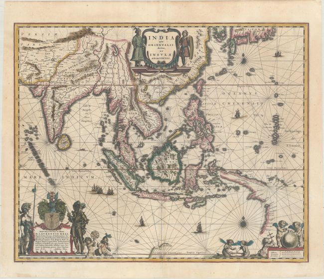
Subject: Southern & Southeast Asia

Period: 1635 (circa)

Publication: Theatre du Monde ou Nouvel Atlas

Color: Hand Color

Size:
20.1 x 16.4 inches
51.1 x 41.7 cm
Download High Resolution Image
(or just click on image to launch the Zoom viewer)

This handsome chart of Southeast Asia includes one of the most detailed images of the sphere of operations of the trading empire of the Dutch East India Company. It extends from India to New Guinea and parts of northern Australia, and north to the southern coast of Japan with a portion of Korea, which is named as an island. This map was a vast improvement over Blaeu's map of the Asian continent and was presented on Mercator's projection in the style of navigational charts. Significantly, it delineates a more correct outline of New Guinea and is the first atlas map to include the discoveries made by the Dutch in the Gulf of Carpentaria -- thus the first recorded European contacts with Australia. Richly embellished with sailing ships, compass roses and three sumptuous cartouches. The cartouche at lower left features the coat of arms and dedication to Laurens Real, Governor General of the East Indies, 1616-18. French text on verso, published between 1635-38.

References: Suarez (SEA) p. 201; Tooley (MCC-60) #226; Van der Krogt (Vol. II) #8400:2.

Condition: B+

Full original color that has been partially refreshed, with light toning along the centerfold at bottom, and a professionally repaired centerfold separation that just enters the map border at bottom

Estimate: $1,400 - $1,700

Sold for: $1,600

Closed on 11/15/2017

Archived