Catalog Archive
Auction 165, Lot 319

Brue's Landmark Map of the West Featuring the Republic of Texas

"Nouvelle Carte du Mexique, du Texas et d'une Partie des Etats Limitrophes...", Brue, Adrien Hubert

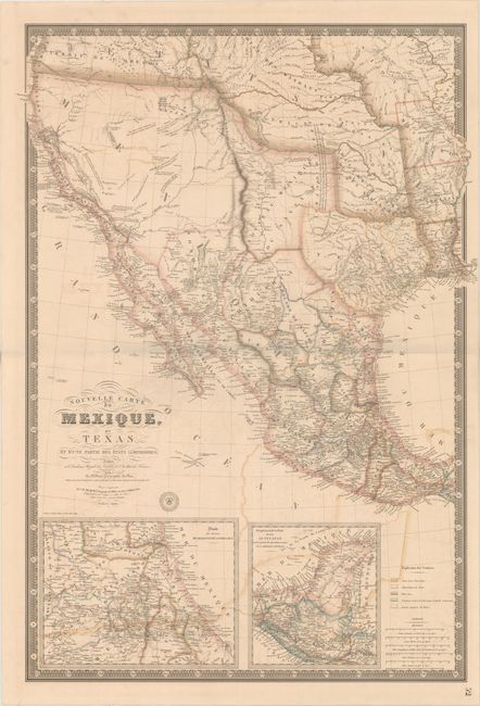
Subject: Western United States & Mexico, Texas, California

Period: 1840 (dated)

Publication:

Color: Hand Color

Size:
25.9 x 36.6 inches
65.8 x 93 cm
Download High Resolution Image
(or just click on image to launch the Zoom viewer)

This is the sixth edition of Brue's 1834 landmark map of the West and only the second edition to depict the Republic of Texas. It was separately issued and published posthumously by Charles Picquet. The map is significant for its depiction of Jedediah Smith's travels in the Great Basin region, showing his route with a solid line from just south of Lac Teguayo (Great Salt Lake) southwest to approximately San Diego, north to R. Wimmelche near the San Joaquin River, and east back to Lac Teguayo, crossing over Mt. St. Joseph (Lassen Peak in northern California) along the way. Wheat describes the first edition of this map as "one of the foundation stones of western mapping" for "it was the first attempt to show the route of Smith's magnificent trek." In addition to Smith's route, the map shows the mythical Lac Timapanogos connecting to the Multnomah River and presumably on to the Pacific Ocean.

This edition is significant for being the first edition with the name Texas added to the title. The Republic of Texas, which is shown in its smaller configuration along the Nueces River. A growing network of roads and wagon trails are depicted from the Red River to points south, and numerous settlements are named including San Antonio de Bexar, San Felipe de Austin, Houston, Nashville and Matagorda to name a few. The map makes note of a Mexican Garrison just north of Tenoxtitlan and also shows two very early railroads connecting Galveston Bay to Columbia and Washington to Fort Monticello. Includes inset maps of the eastern Mexican coast and Central America at bottom. This edition is also notable for updates in the Great Basin based on John Arrowsmith's map of British North America published in 1837.

The map is surrounded by a decorative keyboard-style border that indicates longitude from Paris along with Picquet's engraved and embossed seal to the right of the title cartouche.

References: cf. Wheat (TMW) #404; Rumsey #5396.

Condition: B

Full original color with some color offsetting and a 7" centerfold separation at right that has been archivally repaired.

Estimate: $3,000 - $3,750

Unsold

Closed on 11/15/2017

Archived