Catalog Archive
Auction 165, Lot 230

One of the First Charts of the Florida Gulf Coast in Full Original Color

"Pas Kaart van de Boght van Florida met de Canaal Tusschen Florida en Cuba", Keulen, Johannes van

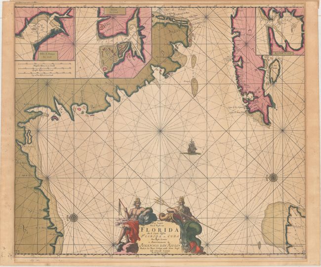
Subject: Florida & Cuba

Period: 1687 (circa)

Publication: De Nieuwe Groote Lichtende Zee-Fakkel, Part IV

Color: Hand Color

Size:
22.9 x 20.1 inches
58.2 x 51.1 cm
Download High Resolution Image
(or just click on image to launch the Zoom viewer)

This uncommon chart is believed to be the first sea chart of the eastern portion of the Gulf of Mexico, and shows Florida's gulf coast from Pensacola to Cape Florida, with the western part of Cuba. The cartography is based in part on Hessel Gerritsz' chart circa 1631, and nearly all the place names on the chart are Spanish. The chart is oriented with north to the left, with a bit of the Yucatan Peninsula shown at lower right. Three insets depict the Cuban harbors: Matanzas Bay, Havana Harbor and Hondo Bay. The elaborate cartouche is flanked by Neptune, god of the sea, and one of the wind gods. This is the third state, with the plate number "15" added at bottom right and left, and a shoal added off the Yucatan peninsula.

References: Burden #591; Martin & Martin, p. 84-85.

Condition: B+

A lovely example with a sharp impression, full original color, and light toning. There is a more pronounced line of toning surrounding the map in the blank margins. There is paper tape along the top edge of the sheet on verso.

Estimate: $3,750 - $4,500

Unsold

Closed on 11/15/2017

Archived