Catalog Archive
Auction 164, Lot 98

"Carte des Decouvertes du Capitaine Parry en 1819 et 1820",

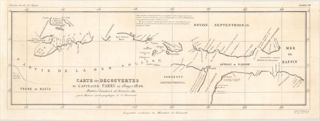
Subject: Canadian Arctic

Period: 1820 (dated)

Publication: Nouvelles Annales des Voyages

Color: Black & White

Size:
25 x 8.5 inches
63.5 x 21.6 cm
Download High Resolution Image
(or just click on image to launch the Zoom viewer)

This map charts the discoveries in the Arctic made by Captain Parry at the beginning of the 19th century. William Edward Parry sailed under John Ross on his voyage of 1818, where Parry became sure that Baffin Bay would lead to the Northwest Passage. Ross had been chastised by the Admiralty for turning back too soon on the 1818 voyage, so Parry was given the command of the Hecla with Lieut. Matthew Liddon commanding the Griper for their voyage of 1819. Parry's subsequent voyage of 1819-20 continued his search of a Northwest Passage from the western part of Baffin Bay along Barrows' Strait (now known as Lancaster Sound and Parry Channel) to Melville Island and Liddon's Gulf. Parry's expedition penetrated very far into the potential passage, so on the expedition's return in 1820, Parry was hailed as a hero and promoted to commander. This map shows the discoveries made by Parry, including several of the southernmost islands of the Queen Elizabeth Islands, including Devon, Cornwallis, Bathurst, and Melville. A notation on Somerset Island, adjacent to the Prince Regent Inlet, explains that the coastline is not precisely drawn as the expedition was not able to approach it due to the ice. Lithographed by G. Engelmann and published in London on November 16, 1820.

References:

Condition: A

Issued folding, now flattened, with a hint of soiling. A chip in the left blank margin has been professionally repaired.

Estimate: $160 - $200

Sold for: $100

Closed on 9/13/2017

Archived