Catalog Archive
Auction 164, Lot 4
"[Lot of 6] Amerique Septentrionale [and] Amerique Meridionale [and] Asie [and] Europe [and] Oceanie [and] France en 1850", Levasseur, Victor
Subject: Continents
Period: 1843-50 (circa)
Publication: Atlas Universel Illustre and Atlas National Illustre
Color: Hand Color
Size:
17.1 x 11.3 inches
43.4 x 28.7 cm
Download High Resolution Image
(or just click on image to launch the Zoom viewer)
(or just click on image to launch the Zoom viewer)
Victor Levasseur's "Atlas National Illustre" and "Atlas Universel Illustre" are among the last decorative atlases published. The maps are all lavishly illustrated with scenes of the countryside, products and activities indigenous to the region.
This lot collects six terrific maps from Levasseur's decorative atlases. Each map is surrounded in an elaborately engraved border containing vignettes representing the region in views, natives, plants, animals, explorers, etc. The illustrations on the maps of the continents were drawn by Raimond Bonheur, father of the famous painter Rosa Bonheur, who trained under her father. Sizes vary slightly.
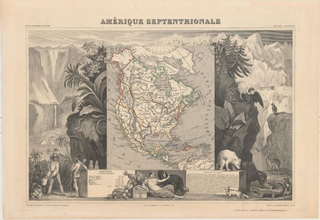
A. . This richly engraved map of North America shows the United States' claims into present-day Canada reflecting the Oregon boundary dispute. The Republic of Texas is shown, and Mexico's northern border is drawn according to the Treaty of 1819 (here misprinted as 1810). Russia is in control of Alaska. The map is surrounded by beautifully engraved scenes of North and Central America including wildlife, a ship stranded in the polar sea, and a Mayan temple.
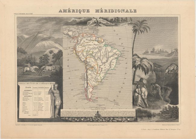
B. Amerique Meridionale. A very decorative 19th century map of the continent shows political divisions in outline color, with good detail of rivers and topography. The map is surrounded by steel engraved scenes including horses, Indians, jaguars, tapirs, and mining as well as female personifications at the top representing the Amazon and La Plata Rivers. The map and surrounding scenes are beautifully drawn.
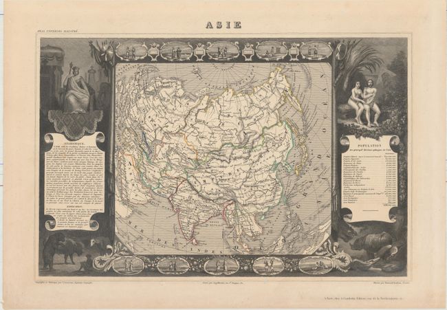
C. Asie. This decorative map of the Asian continent is surrounded by steel engraved vignettes depicting the various peoples of Asia in costume, several exotic animals, and a seated portrait of Adam and Eve. The map depicts the Great Wall of China and extends to include Sumatra and Borneo. Iran is Perse, Thailand is Siam and Sri Lanka is Ceylan. There is an interesting population chart at right totaling only 638,550,000 for the entire continent.
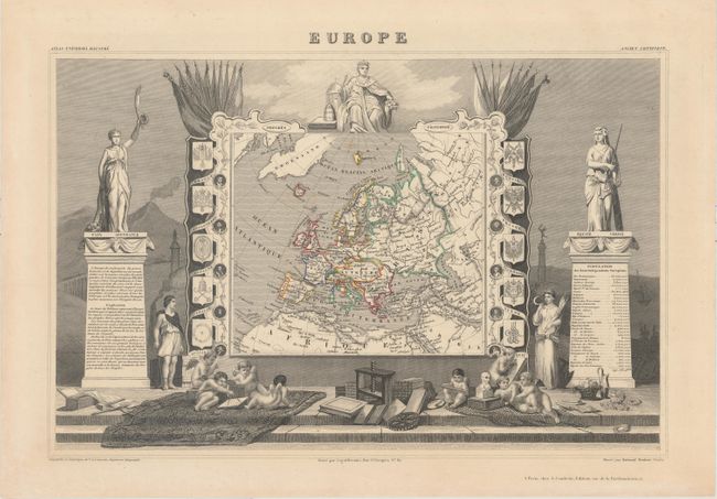
D. Europe. Very handsome map of Europe that includes Greenland, Iceland, and the Arctic Circle. The map itself is framed by medallion portraits and coats of arms down each side, and is set against a background of statues and allegorical figures with a large group of adorable cherubs engaged in academic pursuits filling the foreground.
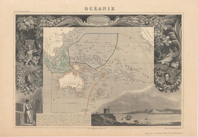
E. Oceanie. This map covers the entire South Pacific including Australia, New Zealand, and Southeast Asia. The map is surrounded by beautifully rendered steel-engraved scenes that feature the natives of the region, portraits of French explorers, a harbor vignette, along with French text describing the region.
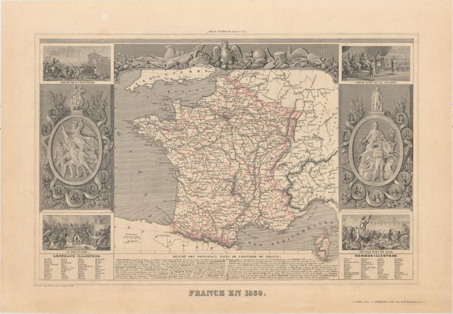
F. France en 1850. This fascinating map of France delineates political divisions and is surrounded by vignettes showing the storming of the Bastille, the coup of 18 Brumaire, Louis XVIII delivering the Charter of 1814, a scene from the July Revolution, and various portraits of revolutionary French leaders.
B. Amerique Meridionale. A very decorative 19th century map of the continent shows political divisions in outline color, with good detail of rivers and topography. The map is surrounded by steel engraved scenes including horses, Indians, jaguars, tapirs, and mining as well as female personifications at the top representing the Amazon and La Plata Rivers. The map and surrounding scenes are beautifully drawn.
C. Asie. This decorative map of the Asian continent is surrounded by steel engraved vignettes depicting the various peoples of Asia in costume, several exotic animals, and a seated portrait of Adam and Eve. The map depicts the Great Wall of China and extends to include Sumatra and Borneo. Iran is Perse, Thailand is Siam and Sri Lanka is Ceylan. There is an interesting population chart at right totaling only 638,550,000 for the entire continent.
D. Europe. Very handsome map of Europe that includes Greenland, Iceland, and the Arctic Circle. The map itself is framed by medallion portraits and coats of arms down each side, and is set against a background of statues and allegorical figures with a large group of adorable cherubs engaged in academic pursuits filling the foreground.
E. Oceanie. This map covers the entire South Pacific including Australia, New Zealand, and Southeast Asia. The map is surrounded by beautifully rendered steel-engraved scenes that feature the natives of the region, portraits of French explorers, a harbor vignette, along with French text describing the region.
F. France en 1850. This fascinating map of France delineates political divisions and is surrounded by vignettes showing the storming of the Bastille, the coup of 18 Brumaire, Louis XVIII delivering the Charter of 1814, a scene from the July Revolution, and various portraits of revolutionary French leaders.