Catalog Archive
Auction 164, Lot 48

Mercator's Foundation Map for the Americas in Full Original Color

"America sive India Nova, ad Magnae Gerardi Mercatoris aui Universalis Imitationem, in Compendium Redacta", Mercator, Michael

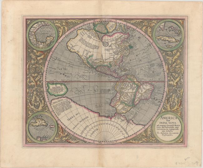
Subject: Western Hemisphere - America

Period: 1628 (circa)

Publication: Gerardi Mercatoris - Atlas sive Cosmographicae

Color: Hand Color

Size:
18.2 x 14.6 inches
46.2 x 37.1 cm
Download High Resolution Image
(or just click on image to launch the Zoom viewer)

This is one of the most famous maps of the Americas and an important foundation map for an American map collection. After the death of his grandfather, Michael Mercator produced this stunning hemispherical map, the only known printed map attributed to him. The map is surrounded by a beautifully engraved floral design and four roundels, one of which contains the title. The other insets include the Gulf of Mexico, Cuba, and Haiti. The geography was patterned after Rumold Mercator's world map of 1587, with a little added detail. There is a large inland lake in Canada, and the St Lawrence River extends nearly halfway across the continent with no Great Lakes. There is a still a bulge in the west coast of South America. The large southern continent extends above the Tropic of Capricorn in the Pacific where there is a very large island of New Guinea. Above North America are two of the four islands of the North Pole, with the great mythical rivers flowing from the pole. The seas are full of mythical islands, including St. Brendain, Frislant and Sept citez. French text on verso, published between 1628-33.

References: Burden #87; Van der Krogt (Vol. I) #9000:1A.

Condition: B+

Lovely original color on watermarked paper with light toning along the centerfold, marginal soiling, and a couple of short tears along the edges of the sheet, well away from the image.

Estimate: $3,250 - $4,000

Unsold

Closed on 9/13/2017

Archived