Catalog Archive
Auction 164, Lot 440

Narborough's Scarce Map of the Strait of Magellan

"To the Rt Honble Robert Earl of Oxford & Mortimer ... This Chart Is Humbly Dedicated", Narbrough, John

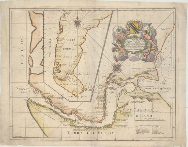
Subject: Strait of Magellan

Period: 1711 (published)

Publication: An Account of Several Late Voyages

Color: Hand Color

Size:
20.4 x 16.3 inches
51.8 x 41.4 cm
Download High Resolution Image
(or just click on image to launch the Zoom viewer)

In 1670, John Narborough was the first Englishman to sail through the Strait of Magellan in both directions; thus demonstrating the falsity of the accepted wisdom that the wind and currents would prevent any eastward passage of the strait. He had been commissioned by James, Duke of York (later James II), to sail to South America to investigate potential trade possibilities. Narborough's expedition proved that a profitable trade with South America was possible, and this set the course of Britain's foreign policy for the next half century. Narborough first published his journal of the voyage in An Account of Several Late Voyages… in 1694, edited by Tancred Robinson and printed by Sam Smith and Benjamin Walford. The book was republished again in 1711. The book included this map of the Strait of Magellan as well as a map of the region around the North Pole. Narborough's map provides a detailed view of the tortuous course of the strait with soundings and safe anchorages carefully noted. There are several notations along the coasts describing the countryside, and a lettered key at bottom right identifies numerous islands found within the strait. A large inset map shows Patagonia and Tierra del Fuego. The map is handsomely adorned with two large compass roses and a title cartouche held aloft by putti and supporting a dedication to Robert Earle of Oxford. This is the second state of the map. Narborough's description of the Strait of Magellan provided the basis for British charts of the strait until the time of Captain Cook.

Both states of the original Narborough map are extremely scarce. We have only found two records of the second state of Narborough's map being on the market in the past 25 years.

References: Sabin #72186.

Condition: B+

On paper with a Strasbourg Lily watermark, light soiling, and some extraneous creases. There are a few tiny worm holes along the centerfold at bottom that have been archivally repaired.

Estimate: $1,100 - $1,400

Sold for: $800

Closed on 9/13/2017

Archived