Catalog Archive
Auction 164, Lot 279

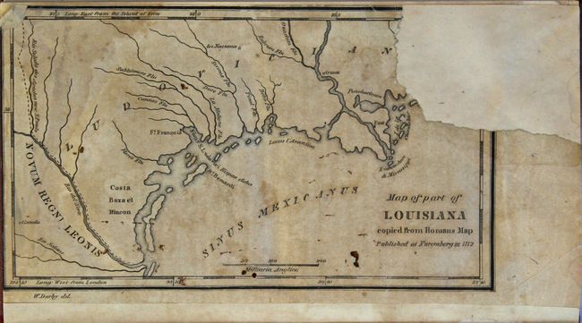
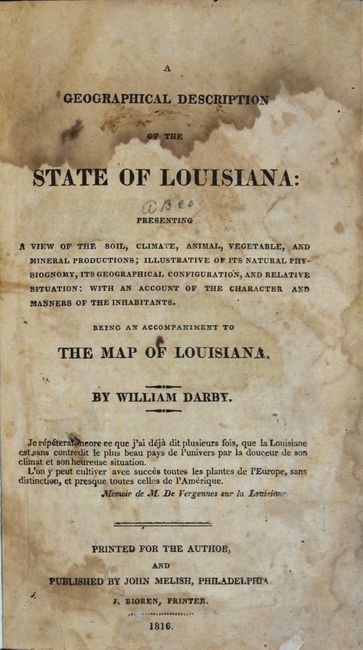
"A Geographical Description of the State of Louisiana: Presenting a View of the Soil, Climate, Animal, Vegetable, and Mineral Productions...", Darby, William

Subject: Louisiana

Period: 1816 (published)

Publication:

Color: Black & White

Size:
4.8 x 7.9 inches
12.2 x 20.1 cm
Download High Resolution Image
(or just click on image to launch the Zoom viewer)

This 270 page volume was produced to accompany the important, separately issued A Map of the State of Louisiana With Part Of The Mississippi Territory by Darby and published by John Melish in Philadelphia (not present). Published only four years after statehood, the text describes the physical geography, flora and fauna, and geology of the state. Included at the back of the volume is the single-page Map of Part of Louisiana Copied from Homans Map that covers the area from the mouth of the Mississippi River southwest to the Rio Grande and shows basic detail of the river systems and coastline. Title page, preface (9 pp.), text (270 pp.), vocabulary (4 pp.), index (10 pp.), errata pages (2 pp.), and single-page map. Octavo, rebound in maroon buckram with gilt title on spine.

References: Howes #D62; Sabin #18528.

Condition: B

The text is generally very good with light toning and scattered foxing mostly in the second half of the volume. The single-page map at the rear of the volume is chipped at top right, with an approximate 1.5 x 1.25" section of image that has been replaced with old paper (map in C condition). The title page is dampstained at top and a previous owner's bookplate is present on the front pastedown. Extremities are very good with only minor wear.

Estimate: $400 - $475

Sold for: $300

Closed on 9/13/2017

Archived