Catalog Archive
Auction 164, Lot 271

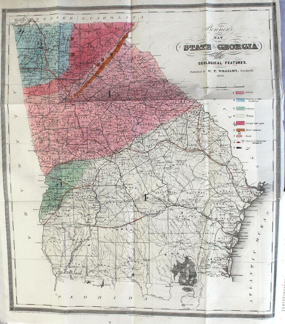
"Bonner's Map of the State of Georgia with the Addition of Its Geological Features [in] Statistics of the State of Georgia...", Bonner, William G.

Subject: Georgia

Period: 1849 (published)

Publication:

Color: Hand Color

Size:
17.2 x 19.5 inches
43.7 x 49.5 cm
Download High Resolution Image
(or just click on image to launch the Zoom viewer)

This map, derived from Bonner's landmark map of Georgia redesigned as a geological map for publication with the book, is the earliest Marcou listing for Georgia. It was published locally from Savannah by W.T. Williams. In it Williams has identified nine geological types, each with distinctive hand coloring, to include Cretaceous, Tertiary, Marble, Coal, etc. Importantly, the large Gold Region is shown in the northern portion of the state. Northern Georgia and western Carolina were the site of the first American gold rush which started in the 1820s-30s. The U.S. Mint, established in 1835, is shown within the gold region next to Dalhonega in Lumpkin County.

The map also locates Elastic Sandstone to suggest the possible extent of Georgia’s diamond fields. Diamonds were first discovered in Georgia in the early 1840s as a byproduct of gold mining in Hall County. A nice summary of the history of these diamond finds is discussed here. The discovery is discussed in the book in the Hall County chapter which says "It is the opinion of several scientific gentlemen, that if proper attention were paid to this subject, large quantities of diamond might be found…"

The map also locates towns and villages, counties, roads, railroads, watershed, etc. The map is surrounded by a ruled border and further decorated by fancy lettering in the title. Engraved by Sherman & Smith and printed at Ackerman's, both in New York City. Bound in the original book "Statistics of the State of Georgia including an account of its Natural Civil, and Ecclesiastical History…and A Correct Map of the State," by George White. The book concentrates on descriptions of each of the counties. In the DeKalb section is one of the earliest mentions and a brief description of Atlanta, which was founded two years earlier. Hardbound, quarter leather and tips over marbled boards. Quarto, 702 pages including index.

This map is a good example of a geological map that was issued to promote the region where economic resources were found. Gold and diamonds certainly captured the public interest so they served an important part of the marketing of Georgia as presented in the publication.

References: Marcou & Marcou #548; Howes #W354.

Condition: A

The map is clean and bright with two faint spots and a short binding tear at right that is confined to the border. Text is bright with occasional faint foxing. There is a bookplate on the front pastedown, and the attractive binding has only minor wear.

Estimate: $700 - $850

Sold for: $350

Closed on 9/13/2017

Archived