Catalog Archive
Auction 164, Lot 237

One of the Earliest Maps of San Francisco

"Official Map of San Francisco, Compiled from the Field Notes of the Official Re-Survey...", Eddy, William M.

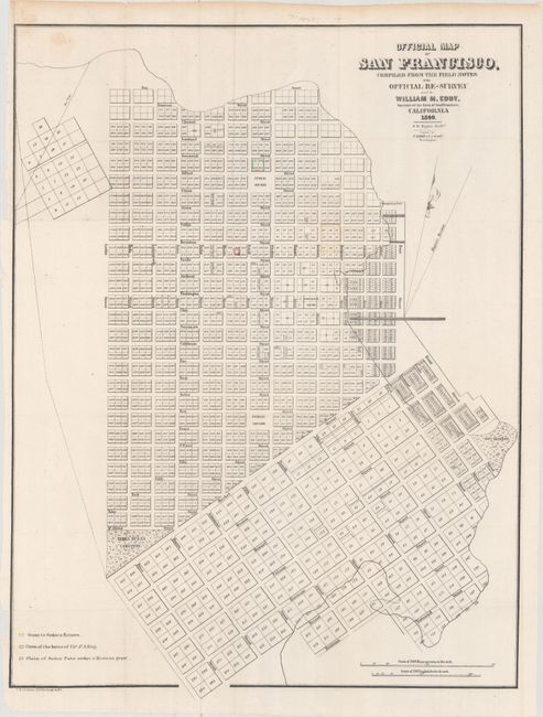
Subject: San Francisco, California

Period: 1849 (dated)

Publication: Sen Ex. Doc 18, 31st Cong., 1st Sess.

Color: Hand Color

Size:
19.2 x 25.3 inches
48.8 x 64.3 cm
Download High Resolution Image
(or just click on image to launch the Zoom viewer)

A scarce and seldom offered street map of San Francisco. It appears to be pre-landfill, with some planned tracts drawn in the bay between Montgomery Fort and the Government Reserve, and in another section including Bryant and Brannan Streets. Terrific detail includes individual tracts numbered and many streets named. The Yerba Buena Cemetery, a Government Reserve, two Public Squares, Portsmith Square, and Fort Montgomery are identified, but no buildings are shown. A colored legend, at lower left, keys to the map and locates a grant to Senora Briones, the claims of the heirs of Col. J. A. King and a claim of Senor Pana under a Mexican Grant. Howes attributes the map to the report "Land Titles in California" by William C. Jones. Drawn by S. W. Higgins and copied by P.M. McGill, C.E.

References: Phillips (Maps) p. 776; Howes #J248; cf. California 49 p. 64.

Condition: B+

Issued folding with a short fold separation that enters the image 1" at left and some minor foxing concentrated in the top left corner.

Estimate: $1,100 - $1,400

Sold for: $900

Closed on 9/13/2017

Archived