Catalog Archive
Auction 163, Lot 87

"Vereinigte Staaten von Nordamerika", Flemming, Carl

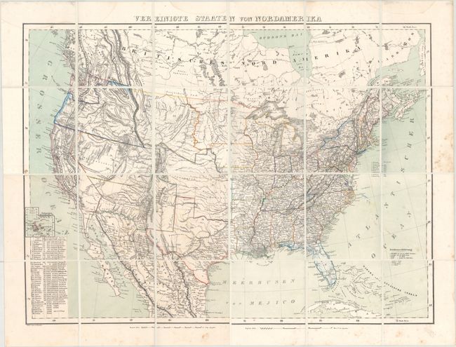
Subject: United States

Period: 1853 (circa)

Publication:

Color: Hand Color

Size:
28.1 x 20.8 inches
71.4 x 52.8 cm
Download High Resolution Image
(or just click on image to launch the Zoom viewer)

This large, detailed map of the United States extends to include part of Canada and Mexico, although information is focused on the United States. The map provided an excellent view of the American West with five large territories encompassing almost the entire west, shown to be mostly the domain of numerous Indian nations. Minosotah Territory takes in the Dakotas with Nebraska Territory stretching to the Rocky Mountains. Indian Territory encompasses present day Oklahoma, Kansas and parts of Nebraska and Colorado. West of the Rockies are the state of California and the territories of New Mexico, Utah and Oregon, which encompasses present-day Oregon, Idaho and eastern Washington, with western Washington separately delineated. The border with Mexico is shown along the Gila River, pre Gadsden Purchase. The map depicts towns, missions, forts, railroads, and canals, and includes a list of the highest mountain peaks. A table lists the states and territories, with populations in 1850, number of counties, and size. Lithography by Handtke. The map was printed on 4 separate sheets, which are here dissected into 24 sections and backed with linen. Folds into a brown cloth clam shell case with a printed paper title label.

References:

Condition: B+

A bright example with original color, minor color offsetting in the Atlantic, and scattered foxing primarily confined to the blank margins. Several light damp stains just enter the border a bit at top. New clam shell case is pristine.

Estimate: $400 - $500

Unsold

Closed on 6/14/2017

Archived