Catalog Archive
Auction 163, Lot 437

"Perrin du Lac's Reise in die Beyden Louisianen Unter die Wilden Volkerschaften am Missouri, durch die Vereinigten Staaten und die Provinzen am Ohio in den Jahren 1801, 1802, und 1803...",

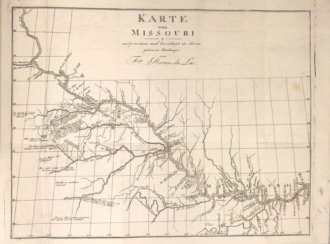
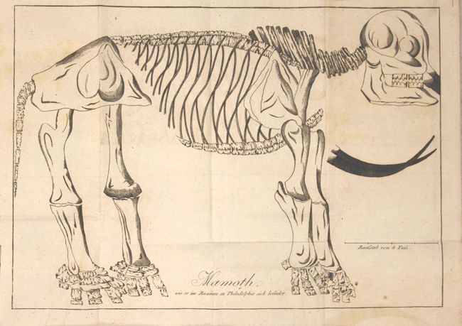
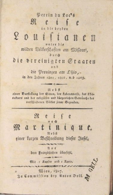
Subject: Exploration & Surveys

Period: 1807 (published)

Publication:

Color: Black & White

Size:
4.9 x 8 inches
12.4 x 20.3 cm
Download High Resolution Image
(or just click on image to launch the Zoom viewer)

This is the first German edition of Francois Marie Perrin du Lac's account of his voyage through the trans-Mississippi region. Perrin du Lac arrived in New York in 1801 and traveled west along the Ohio River to St. Louis. He then claimed to join a fur trading expedition in the summer of 1802 traveling up the Missouri River to South Dakota. Perrin du Lac's account is known as one of the most important accounts of the Upper Missouri fur trade in the early 19th century. His work included extensive information on the Indian tribes along the river, the Anglo-French rivalry in the fur trade, and the early history of Louisiana. Although the veracity of his account has been substantiated, the source of his information has come into question. Many scholars believe that Perrin du Lac did not make the journey up the Missouri River himself, and that his account is based on information obtained from fur traders in St. Louis, possibly Pierre Menard or Jean Baptiste Trudeau.

Accompanying his account is a map of the Missouri River and its tributaries, Karte von Missouri Aufgenomen und Berichtigt in Ihrem Ganzen Umfange von Frois Perrin du Lac (12.7 x 9.5"), extending from central South Dakota to where the river flows into the Mississippi River at St. Louis. Howes claims that this map "is the best of that region published at the time." There is excellent detail of the extensive river system and villages, with notations throughout. The route of James Mackay's 1796 expedition up the Missouri River is also shown, and Wheat believes that this map was based in part on Mackay's original map. Mackay's map was known to have been carried by Lewis & Clark on their famous trek west, and Perrin du Lac's map of Missouri represents the "only published form in which the work of Mackay and (in part) of Evans could be found for upwards of a century" (Wheat. p. 164).

Perrin du Lac's account was first published in two French editions in 1805, and subsequently in one English and two German editions all appearing in 1807. The French edition did not include a map, and the map in the German editions was a newly engraved, reduced-size edition of the original French map. Also included in the French and German editions is a fold-out engraving of a mammoth skeleton from a museum in Philadelphia.

363 pp., folding map, folding plate. Hardbound in quarter leather with tips over marbled paper covers with black leather title label and gilt titling on spine.

References: Howes #P244; Sabin #61014; Wagner & Camp #3:4; Wheat (TMW) #256.

Condition: B+

The map is overall very clean and bright with minor offsetting and two light spots of foxing at right. The plate has minor offsetting and light scattered foxing. The text is generally very good with very light toning and foxing. The binding is tight and the covers are worn with several abrasions.

Estimate: $1,400 - $1,700

Unsold

Closed on 6/14/2017

Archived