Catalog Archive
Auction 163, Lot 37

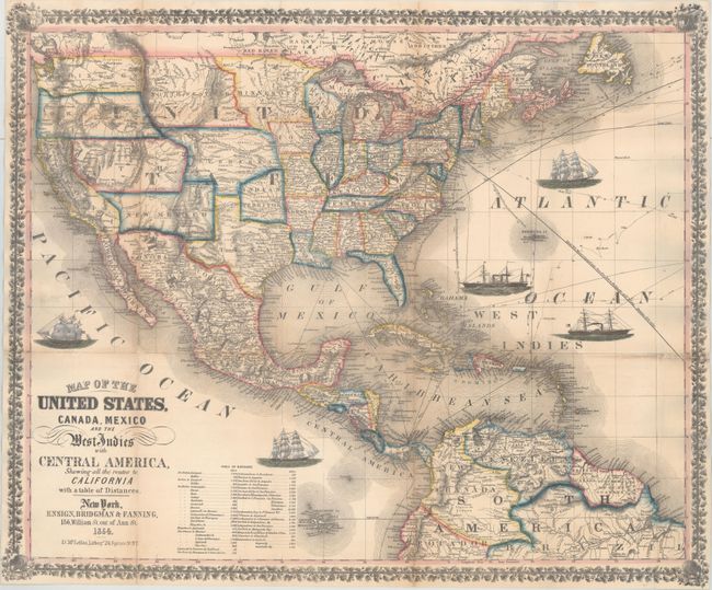
Decorative Map Published During the California Gold Rush

"Map of the United States, Canada, Mexico and the West Indies with Central America, Showing All the Routes to California with a Table of Distances", Ensign, Bridgman & Fanning

Subject: North America

Period: 1854 (dated)

Publication:

Color: Hand Color

Size:
26 x 21.7 inches
66 x 55.1 cm
Download High Resolution Image
(or just click on image to launch the Zoom viewer)

This pocket map was published at the end of the California Gold Rush and was created to show "all the routes to California." This was also a time when many territorial borders were in interesting configurations. Eight large territories make up the majority of the Western United States, which would later become 15 different states. These territories include Washington, Oregon, Northwest, Minnesota, Utah, New Mexico, Nebraska, and Indian Territory. The map is filled with many details including rivers, railroads, wagon roads and Indian tribes and extends to include portions of Canada, Central America, northern South America and all of the Caribbean islands. Sea routes between various ports are displayed along with 5 vignettes of sailboats and steamships and at lower left is a table listing distances between ports. Surrounded by a decorative border. The original boards are no longer present.

References: Wheat (TMW) #804.

Condition: B+

Issued folding, now flattened and backed in heavy tissue to provide support and repair fold separations and a few minor tears. There are a few very small areas of loss around fold intersections, and light toning along a few folds.

Estimate: $1,800 - $2,100

Sold for: $1,200

Closed on 6/14/2017

Archived