Catalog Archive
Auction 163, Lot 368

Rare and Important Map That Helped Establish Independent Texas' Eastern Border

"Map of the River Sabine from Its Mouth on the Gulf of Mexico in the Sea to Logan's Ferry...", U.S. Government

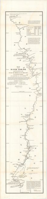
Subject: Texas-Louisiana Border

Period: 1842 (published)

Publication: Sen. Doc. 199, 27th Cong., 2nd Sess.

Color: Black & White

Size:
7.2 x 34.3 inches
18.3 x 87.1 cm
Download High Resolution Image
(or just click on image to launch the Zoom viewer)

This is one of six maps issued with the report on the boundary survey between the Republic of Texas and the United States. The act admitting Louisiana to statehood in 1812 contained a clause defining its original boundaries. When Texas declared its independence in 1835, these borders came into question. This survey was made shortly thereafter. This report of the Joint United States-Texas Boundary Commission depicted the eastern border of Texas for the first time. The map depicts the boundary starting from a mound erected at the mouth of the river and follows up the river to Logan's Ferry (where the boundary ceases to follow the river). The map is minutely detailed and filled with fascinating notations. A rare and important part of Texas' cartographic history. Drawn by Lieut. T.J. Lee, U.S. Topographical Engineers and engraved by W.J. Stone.

References: Claussen & Friis #417; Day #952; Martin & Martin p. 36.

Condition: B+

Issued folding with occasional faint staining.

Estimate: $550 - $700

Sold for: $350

Closed on 6/14/2017

Archived