Catalog Archive
Auction 163, Lot 31

"Amerique Septentrionale ou Partie des Indes Occidentales", Nolin, Jean Batiste

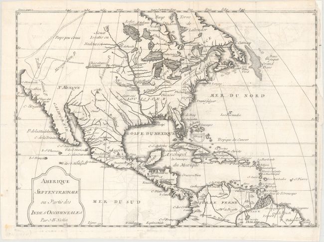
Subject: Colonial North America

Period: 1722 (circa)

Publication: Voyages de Francois Coreal au Indes Occidentales

Color: Black & White

Size:
11.6 x 8.4 inches
29.5 x 21.3 cm
Download High Resolution Image
(or just click on image to launch the Zoom viewer)

This scarce map was published in a French account of the voyages of Francisco (Francois) Coreal, a Spaniard, to the West Indies from 1666-97. The authenticity of Coreal's account, and indeed his identity itself, has been called into question due to the fact that there is no Spanish edition of his account, and some therefore believe that Coreal's account is actually a compilation of the travels and discoveries of other explorers. This map appeared at the beginning of the first volume, and illustrates several cartographic misconceptions. The R. Longue extends west from the Mississippi River to Gnacsitares, based on the reports of Baron Lahontan. Southern Florida is composed of several large islands and a narrow peninsula. A notation in the northwest indicates that the area is little known, and several dotted lines allude to the possibility of a northwest passage or River of the West, which would begin to appear frequently on French maps in the mid-eighteenth century. The mythical Parime L. still appears in South America.

Jean Baptiste Nolin is given credit in the title cartouche, as the map is largely copied from his folio-sized map L'Amerique ou le Nouveau Continent [1720], however it is unlikely that Nolin was involved in creating this smaller edition.

References: Sabin #16781.

Condition: B+

Issued folding on watermarked paper with light offsetting and an extraneous crease at bottom left. Several short fold separations in the map and a chip at right just entering the border have been professionally repaired on verso with old paper.

Estimate: $300 - $375

Sold for: $170

Closed on 6/14/2017

Archived