Catalog Archive
Auction 163, Lot 30

Sanson/Jaillot's Map of North America

"Amerique Septentrionale Divisee en ses Principales Parties, ou sont Distingues les uns des Autres les Estats...", Sanson/Jaillot

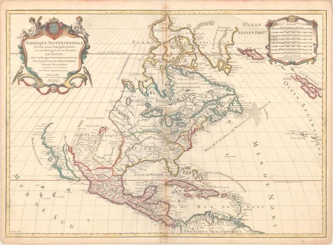
Subject: Colonial North America

Period: 1719 (dated)

Publication: Atlas Francois

Color: Hand Color

Size:
25.3 x 18 inches
64.3 x 45.7 cm
Download High Resolution Image
(or just click on image to launch the Zoom viewer)

Hubert Jaillot, successor to Nicolas Sanson, was the most influential French cartographer of his day. In partnership with Sanson's sons, Jaillot revised and reissued a number of Sanson's maps, one of which is this map of North America first published in 1650. While maintaining much of the same information as Sanson's map, this fifth state demonstrates the changing cartography of the continent at the beginning of the eighteenth century.

In Jaillot's first edition (separately published in 1674), the depiction of the Mississippi River basin is based upon Richelet's 1670 literal translation of the route traced by De Soto. Jaillot succeeded for the first time in transposing information from the discovery of the Mississippi in 1542 to a map with any pretense of accuracy, some 133 years later. Although Jaillot maintained the fictitious Bahia del Spiritu Santo/Mer Pequina found on both the earlier Chauves map (1584) and De Laet's map (1630), the easternmost river feeding the bay carries the name Chacagua River. Chacagua was the Indian name for the Mississippi River. This 1719 edition largely follows the same model as the first edition, but the Missisipi is delineated in the Franquelin/Coronelli spirit, with detail in the headwaters, showing the Ohio River, and adding considerable new geography in the Great Lakes.

In the West, California is no longer in island shape and appears more like a peninsula, though the question of its insularity remains due to a gap at the head of the Mare Vermejo and a missing northern coastline. The seventh and final state in 1783 clearly showed California as a peninsula, with the northwest coast of the U.S. also delineated. Also corrected in this edition is the route of the Rio del Norte which now flows into the Gulf of Mexico instead of the Gulf of California.

Other interesting features of this map include a mythical lake in present-day Georgia, and the naming of the northern colonies of Mariland, Pensilvanie, and Nuov. York. The French claim in the southeast is named Caroline. The lion's share of today's United States is divided between Louisiane and Nouveau Mexique. There are scores of place names, forts, and Indian tribes. A lovely title cartouche by C. Simonneau with Native Americans and tropical birds appears at upper left, balanced by the distance scale cartouche on the right. Engraved by Louis Cordier.

References: Burden #709; McCorkle #719.8; McLaughlin #101.

Condition: B+

Watermarked paper with original outline color and later color in the cartouche. There is toning along the centerfold and a short centerfold separation at bottom that has been archivally repaired.

Estimate: $1,400 - $1,700

Unsold

Closed on 6/14/2017

Archived